Sultānpur geodata
Sultānpur (Uttar Pradesh) is a populated place; located in India in Asia/Kolkata (GMT+5.5) time zone. With population of 110,368 people, there are 404 cities with bigger population in this country. Compared to other cities in India, 72.5% of cities are located further ↓South; 76.8% of cities are located further ←West and 67.6% of cities have higher elevation than Sultānpur. Note1


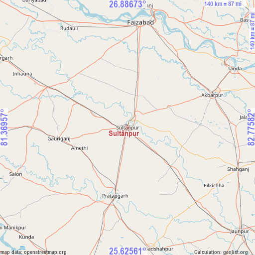
Sultānpur GPS coordinates[2]
26° 15' 28.368" North, 82° 4' 21.684" East
| Map corner | latitude | longitude |
|---|---|---|
| Upper-left | 26.88673°, | 81.36957° |
| Center: | 26.25788°, | 82.07269° |
| Lower-right: | 25.62561°, | 82.77582° |
| Map W x H: | 140.2×140.2 km | = 87.1×87.1mi |
| max Lat: | 34.9274° ⇑27.5% North |
| Sultānpur: | 26.25788° |
| min Lat: | ⇓72.5% South 8.09008° |
| min Long | Sultānpur | max Long |
| 68.82655° | 82.07269° | 96.81° |
| W 76.8%⇐ | ⇒23.2% E |
Elevation
Elevation of Sultānpur is 104 m = 341 ft, and this is 191.6 m = 629 ft below average elevation for this country.
| Max E: |
3681 m = 12077 ft | 67.6% |
| Avg. | 295.6 m = 970 ft | |
| Sultānpur | 104 m = 341 ft | |
Min E: |
1 m = 3 ft | 32.4% |
See also: Sultānpur elevation on elevation.city.
Geographical zone
Sultānpur is located in North temperate zone (between Tropic of Cancer and the Arctic Circle). Distance of this Northern Tropic circle is 313.7 km =194.9 mi to South.| Distance of | km | miles | from Sultānpur |
|---|---|---|---|
| North Pole | 7087.5 | 4404 | to North |
| Arctic Circle | 4481.6 | 2784.7 | to North |
| Tropic Cancer | 313.7 | 194.9 | to South |
| Equator | 2919.6 | 1814.2 | to South |


Nearby cities:
15 places around Sultānpur: (largest is in red/bold)
• Akbarpur
49.8 km =30.9 mi,  67°
67°
• Amethī
28.9 km =18 mi,  247°
247°
• Antu
28.1 km =17.5 mi,  217°
217°
• Bela
38.3 km =23.8 mi,  191°
191°
• Bīkāpur
38 km =23.6 mi,  9°
9°
• Dostpur
39.8 km =24.7 mi,  87°
87°
• Fyzābād
58.1 km =36.1 mi, 7°
• Goshāinganj
46.4 km =28.8 mi,  41°
41°
• Jais
52.3 km =32.5 mi,  270°
270°
• Kādīpur
31.3 km =19.4 mi,  108°
108°
• Lālganj
51.6 km =32.1 mi,  225°
225°
• Musāfir-Khāna
30.7 km =19.1 mi,  295°
295°
• Parshādepur
61.5 km =38.2 mi, 250°
• Patti
39.5 km =24.5 mi,  161°
161°
• Pratāpgarh
42.4 km =26.3 mi,  197°
197°
Sources, notices
• [Note1] Compared only with cities in India existing in our database
• [Src1] Map data: © OpenStreetMap contributors (CC-BY-SA)
• [Src2] Other city data from geonames.org with taken over terms of usage.
• [Src3] Geographical zone / Annual Mean Temperature by Robert A. Rohde @ Wikipedia
