Antu geodata
Antu (Uttar Pradesh) is a populated place; located in India in Asia/Kolkata (GMT+5.5) time zone. With population of 8,316 people, there are 3098 cities with bigger population in this country. Compared to other cities in India, 70.8% of cities are located further ↓South; 76.2% of cities are located further ←West and 68.5% of cities have higher elevation than Antu. Note1


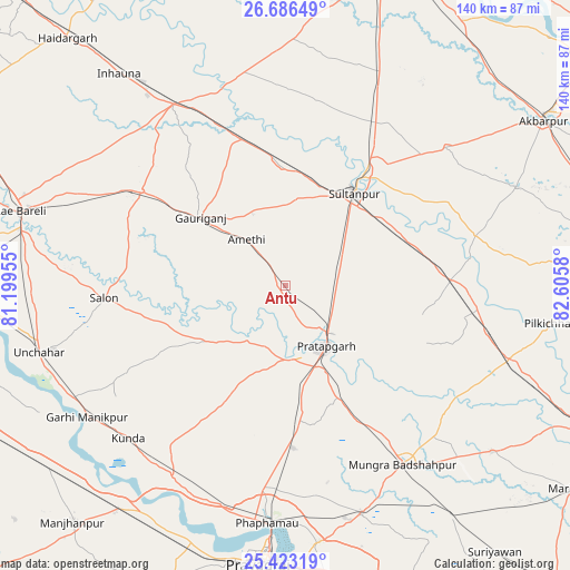
Antu GPS coordinates[2]
26° 3' 23.544" North, 81° 54' 9.612" East
| Map corner | latitude | longitude |
|---|---|---|
| Upper-left | 26.68649°, | 81.19955° |
| Center: | 26.05654°, | 81.90267° |
| Lower-right: | 25.42319°, | 82.6058° |
| Map W x H: | 140.5×140.5 km | = 87.3×87.3mi |
| max Lat: | 34.9274° ⇑29.2% North |
| Antu: | 26.05654° |
| min Lat: | ⇓70.8% South 8.09008° |
| min Long | Antu | max Long |
| 68.82655° | 81.90267° | 96.81° |
| W 76.2%⇐ | ⇒23.8% E |
Elevation
Elevation of Antu is 100 m = 328 ft, and this is 195.6 m = 642 ft below average elevation for this country.
| Max E: |
3681 m = 12077 ft | 68.5% |
| Avg. | 295.6 m = 970 ft | |
| Antu | 100 m = 328 ft | |
Min E: |
1 m = 3 ft | 31.5% |
See also: India elevation on elevation.city.
Geographical zone
Antu is located in North temperate zone (between Tropic of Cancer and the Arctic Circle). Distance of this Northern Tropic circle is 291.3 km =181 mi to South.| Distance of | km | miles | from Antu |
|---|---|---|---|
| North Pole | 7109.8 | 4417.8 | to North |
| Arctic Circle | 4504 | 2798.7 | to North |
| Tropic Cancer | 291.3 | 181 | to South |
| Equator | 2897.2 | 1800.2 | to South |


Nearby cities:
15 places around Antu: (largest is in red/bold)
• Amethī
14.8 km =9.2 mi,  318°
318°
• Bela
17.8 km =11.1 mi,  148°
148°
• Dostpur
61.7 km =38.3 mi,  66°
66°
• Jais
42.3 km =26.3 mi,  303°
303°
• Kunda
54.2 km =33.7 mi,  225°
225°
• Kādīpur
48.3 km =30 mi,  75°
75°
• Lālganj
24.2 km =15 mi, 234°
• Mau Aimma
40.2 km =25 mi,  177°
177°
• Musāfir-Khāna
37.3 km =23.2 mi,  343°
343°
• Parshādepur
41.1 km =25.5 mi,  272°
272°
• Patti
33.3 km =20.7 mi,  116°
116°
• Phulpur
59.5 km =37 mi,  161°
161°
• Pratāpgarh
18.4 km =11.4 mi,  167°
167°
• Salon
44.9 km =27.9 mi, 266°
• Sultānpur
28.1 km =17.5 mi,  37°
37°
Sources, notices
• [Note1] Compared only with cities in India existing in our database
• [Src1] Map data: © OpenStreetMap contributors (CC-BY-SA)
• [Src2] Other city data from geonames.org with taken over terms of usage.
• [Src3] Geographical zone / Annual Mean Temperature by Robert A. Rohde @ Wikipedia
