Anjār geodata
Anjār (Gujarat) is a populated place; located in India in Asia/Kolkata (GMT+5.5) time zone. With population of 66,888 people, there are 649 cities with bigger population in this country. Compared to other cities in India, 52.4% of cities are located further ↓South; 99.5% of cities are located further →East and 74.7% of cities have higher elevation than Anjār. Note1


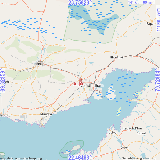
Anjār GPS coordinates[2]
23° 6' 47.376" North, 70° 1' 36.156" East
| Map corner | latitude | longitude |
|---|---|---|
| Upper-left | 23.75828°, | 69.32359° |
| Center: | 23.11316°, | 70.02671° |
| Lower-right: | 22.46493°, | 70.72984° |
| Map W x H: | 143.8×143.8 km | = 89.4×89.4mi |
| max Lat: | 34.9274° ⇑47.6% North |
| Anjār: | 23.11316° |
| min Lat: | ⇓52.4% South 8.09008° |
| min Long | Anjār | max Long |
| 68.82655° | 70.02671° | 96.81° |
| W 0.5%⇐ | ⇒99.5% E |
Elevation
Elevation of Anjār is 69 m = 226 ft, and this is 226.6 m = 743 ft below average elevation for this country.
| Max E: |
3681 m = 12077 ft | 74.7% |
| Avg. | 295.6 m = 970 ft | |
| Anjār | 69 m = 226 ft | |
Min E: |
1 m = 3 ft | 25.3% |
See also: Anjār elevation on elevation.city.
Geographical zone
Anjār is located in North Torrid zone (between Equator and Tropic of Cancer). Distance of this Northern Tropic circle is 36 km =22.4 mi to North.| Distance of | km | miles | from Anjār |
|---|---|---|---|
| North Pole | 7437.1 | 4621.2 | to North |
| Arctic Circle | 4831.2 | 3002 | to North |
| Tropic Cancer | 36 | 22.4 | to North |
| Equator | 2569.9 | 1596.9 | to South |


Nearby cities:
15 places around Anjār: (largest is in red/bold)
• Bedi
68 km =42.3 mi,  178°
178°
• Bhachāu
38.3 km =23.8 mi,  57°
57°
• Bhuj
39.7 km =24.7 mi,  293°
293°
• Dhrol
72.8 km =45.2 mi,  146°
146°
• Gāndhīdhām
11.4 km =7.1 mi,  106°
106°
• Jamnagar
71.3 km =44.3 mi, 176°
• Jodiya Bandar
51.3 km =31.9 mi, 149°
• Kāndla
21.4 km =13.3 mi, 114°
• Morbi
89.3 km =55.5 mi, 111°
• Mundra
43.6 km =27.1 mi,  225°
225°
• Māndvi
75.7 km =47 mi,  245°
245°
• Roha
77.8 km =48.3 mi,  276°
276°
• Rāpar
81.4 km =50.6 mi,  51°
51°
• Sikka
78.1 km =48.5 mi,  194°
194°
• Tankāra
89.8 km =55.8 mi,  124°
124°
Sources, notices
• [Note1] Compared only with cities in India existing in our database
• [Src1] Map data: © OpenStreetMap contributors (CC-BY-SA)
• [Src2] Other city data from geonames.org with taken over terms of usage.
• [Src3] Geographical zone / Annual Mean Temperature by Robert A. Rohde @ Wikipedia
