Kāndla geodata
Kāndla (Gujarat) is a populated place; located in India in Asia/Kolkata (GMT+5.5) time zone. With population of 25,845 people, there are 1647 cities with bigger population in this country. Compared to other cities in India, 52% of cities are located further ↓South; 99.3% of cities are located further →East and 98.3% of cities have higher elevation than Kāndla. Note1


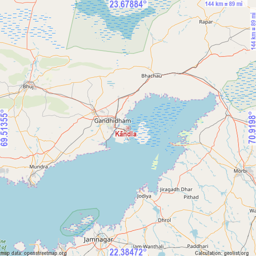
Kāndla GPS coordinates[2]
23° 1' 59.988" North, 70° 13' 0.012" East
| Map corner | latitude | longitude |
|---|---|---|
| Upper-left | 23.67884°, | 69.51355° |
| Center: | 23.03333°, | 70.21667° |
| Lower-right: | 22.38472°, | 70.9198° |
| Map W x H: | 143.9×143.9 km | = 89.4×89.4mi |
| max Lat: | 34.9274° ⇑48% North |
| Kāndla: | 23.03333° |
| min Lat: | ⇓52% South 8.09008° |
| min Long | Kāndla | max Long |
| 68.82655° | 70.21667° | 96.81° |
| W 0.7%⇐ | ⇒99.3% E |
Elevation
Elevation of Kāndla is 8 m = 26 ft, and this is 287.6 m = 944 ft below average elevation for this country.
| Max E: |
3681 m = 12077 ft | 98.3% |
| Avg. | 295.6 m = 970 ft | |
| Kāndla | 8 m = 26 ft | |
Min E: |
1 m = 3 ft | 1.7% |
See also: India elevation on elevation.city.
Geographical zone
Kāndla is located in North Torrid zone (between Equator and Tropic of Cancer). Distance of this Northern Tropic circle is 44.9 km =27.9 mi to North.| Distance of | km | miles | from Kāndla |
|---|---|---|---|
| North Pole | 7446 | 4626.7 | to North |
| Arctic Circle | 4840.1 | 3007.5 | to North |
| Tropic Cancer | 44.9 | 27.9 | to North |
| Equator | 2561.1 | 1591.4 | to South |


Nearby cities:
15 places around Kāndla: (largest is in red/bold)
• Anjār
21.4 km =13.3 mi,  294°
294°
• Bedi
61.7 km =38.3 mi,  196°
196°
• Bhachāu
32.2 km =20 mi,  23°
23°
• Bhuj
61.1 km =38 mi, 293°
• Dhrol
55.8 km =34.7 mi,  158°
158°
• Gāndhīdhām
10.2 km =6.3 mi,  303°
303°
• Jamnagar
64.2 km =39.9 mi,  193°
193°
• Jodiya Bandar
35.9 km =22.3 mi,  169°
169°
• Morbi
68 km =42.3 mi,  110°
110°
• Mundra
55.1 km =34.2 mi,  246°
246°
• Paddhari
77.2 km =48 mi,  149°
149°
• Rāpar
74.4 km =46.2 mi,  36°
36°
• Sikka
77.1 km =47.9 mi,  209°
209°
• Tankāra
68.8 km =42.8 mi,  127°
127°
• Wānkāner
88 km =54.7 mi,  122°
122°
Sources, notices
• [Note1] Compared only with cities in India existing in our database
• [Src1] Map data: © OpenStreetMap contributors (CC-BY-SA)
• [Src2] Other city data from geonames.org with taken over terms of usage.
• [Src3] Geographical zone / Annual Mean Temperature by Robert A. Rohde @ Wikipedia
