Kāmākhyānagar geodata
Kāmākhyānagar (Odisha) is a populated place; located in India in Asia/Kolkata (GMT+5.5) time zone. With population of 15,818 people, there are 2388 cities with bigger population in this country. Compared to other cities in India, 61.9% of cities are located further ↑North; 85.8% of cities are located further ←West and 75.2% of cities have higher elevation than Kāmākhyānagar. Note1


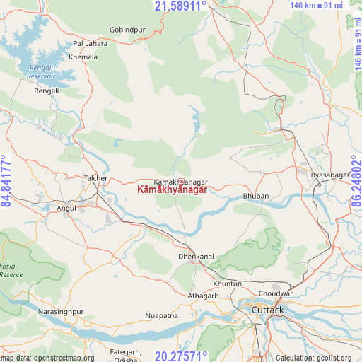
Kāmākhyānagar GPS coordinates[2]
20° 56' 1.86" North, 85° 32' 41.604" East
| Map corner | latitude | longitude |
|---|---|---|
| Upper-left | 21.58911°, | 84.84177° |
| Center: | 20.93385°, | 85.54489° |
| Lower-right: | 20.27571°, | 86.24802° |
| Map W x H: | 146×146 km | = 90.7×90.7mi |
| max Lat: | 34.9274° ⇑61.9% North |
| Kāmākhyānagar: | 20.93385° |
| min Lat: | ⇓38.1% South 8.09008° |
| min Long | Kāmākhyānaga | max Long |
| 68.82655° | 85.54489° | 96.81° |
| W 85.8%⇐ | ⇒14.2% E |
Elevation
Elevation of Kāmākhyānagar is 67 m = 220 ft, and this is 228.6 m = 750 ft below average elevation for this country.
| Max E: |
3681 m = 12077 ft | 75.2% |
| Avg. | 295.6 m = 970 ft | |
| Kāmākhyānagar | 67 m = 220 ft | |
Min E: |
1 m = 3 ft | 24.8% |
See also: India elevation on elevation.city.
Geographical zone
Kāmākhyānagar is located in North Torrid zone (between Equator and Tropic of Cancer). Distance of this Northern Tropic circle is 278.3 km =172.9 mi to North.| Distance of | km | miles | from Kāmākhyānagar |
|---|---|---|---|
| North Pole | 7679.4 | 4771.8 | to North |
| Arctic Circle | 5073.5 | 3152.5 | to North |
| Tropic Cancer | 278.3 | 172.9 | to North |
| Equator | 2327.6 | 1446.3 | to South |


Nearby cities:
15 places around Kāmākhyānagar: (largest is in red/bold)
• Angul
47.2 km =29.3 mi,  257°
257°
• Bhuban
30.5 km =19 mi,  100°
100°
• Bhubaneshwar
79.5 km =49.4 mi,  157°
157°
• Bālugaon
95.3 km =59.2 mi,  208°
208°
• Bānki
61.7 km =38.3 mi,  181°
181°
• Cuttack
62.7 km =39 mi,  146°
146°
• Daitari
28.2 km =17.5 mi,  49°
49°
• Dhenkānāl
31.2 km =19.4 mi,  170°
170°
• Jatani
87.7 km =54.5 mi, 168°
• Jājpur
82.9 km =51.5 mi, 96°
• Kantilo
73.5 km =45.7 mi, 209°
• Khurda
83.9 km =52.1 mi, 174°
• Pipili
96 km =59.7 mi, 161°
• Tālcher
32.4 km =20.1 mi,  273°
273°
• Āthagarh
46.9 km =29.1 mi, 169°
Sources, notices
• [Note1] Compared only with cities in India existing in our database
• [Src1] Map data: © OpenStreetMap contributors (CC-BY-SA)
• [Src2] Other city data from geonames.org with taken over terms of usage.
• [Src3] Geographical zone / Annual Mean Temperature by Robert A. Rohde @ Wikipedia
