Angul geodata
Angul (Odisha) is a populated place; located in India in Asia/Kolkata (GMT+5.5) time zone. With population of 44,386 people, there are 996 cities with bigger population in this country. Compared to other cities in India, 62.2% of cities are located further ↑North; 84.6% of cities are located further ←West and 64.2% of cities have higher elevation than Angul. Note1


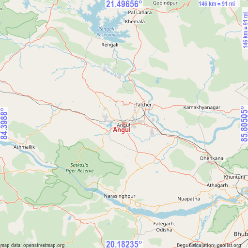
Angul GPS coordinates[2]
20° 50' 27.204" North, 85° 6' 6.912" East
| Map corner | latitude | longitude |
|---|---|---|
| Upper-left | 21.49656°, | 84.3988° |
| Center: | 20.84089°, | 85.10192° |
| Lower-right: | 20.18235°, | 85.80505° |
| Map W x H: | 146.1×146.1 km | = 90.8×90.8mi |
| max Lat: | 34.9274° ⇑62.2% North |
| Angul: | 20.84089° |
| min Lat: | ⇓37.8% South 8.09008° |
| min Long | Angul | max Long |
| 68.82655° | 85.10192° | 96.81° |
| W 84.6%⇐ | ⇒15.4% E |
Elevation
Elevation of Angul is 126 m = 413 ft, and this is 169.6 m = 556 ft below average elevation for this country.
| Max E: |
3681 m = 12077 ft | 64.2% |
| Avg. | 295.6 m = 970 ft | |
| Angul | 126 m = 413 ft | |
Min E: |
1 m = 3 ft | 35.8% |
See also: Angul elevation on elevation.city.
Geographical zone
Angul is located in North Torrid zone (between Equator and Tropic of Cancer). Distance of this Northern Tropic circle is 288.6 km =179.3 mi to North.| Distance of | km | miles | from Angul |
|---|---|---|---|
| North Pole | 7689.8 | 4778.2 | to North |
| Arctic Circle | 5083.9 | 3159 | to North |
| Tropic Cancer | 288.6 | 179.3 | to North |
| Equator | 2317.3 | 1439.9 | to South |


Nearby cities:
15 places around Angul: (largest is in red/bold)
• Baud
80.6 km =50.1 mi,  269°
269°
• Bhuban
76.1 km =47.3 mi,  86°
86°
• Bālugaon
73.7 km =45.8 mi,  179°
179°
• Bānki
67.9 km =42.2 mi,  139°
139°
• Cuttack
91 km =56.5 mi,  117°
117°
• Daitari
73.2 km =45.5 mi,  66°
66°
• Deogarh
86.4 km =53.7 mi,  333°
333°
• Dhenkānāl
55.4 km =34.4 mi,  111°
111°
• Kaintragarh
60.4 km =37.5 mi,  257°
257°
• Kantilo
54.1 km =33.6 mi,  170°
170°
• Khurda
90.7 km =56.4 mi, 143°
• Kāmākhyānagar
47.2 km =29.3 mi,  77°
77°
• Nayāgarh
79.2 km =49.2 mi, 180°
• Tālcher
18.2 km =11.3 mi,  48°
48°
• Āthagarh
65.5 km =40.7 mi, 123°
Sources, notices
• [Note1] Compared only with cities in India existing in our database
• [Src1] Map data: © OpenStreetMap contributors (CC-BY-SA)
• [Src2] Other city data from geonames.org with taken over terms of usage.
• [Src3] Geographical zone / Annual Mean Temperature by Robert A. Rohde @ Wikipedia
