Itimādpur geodata
Itimādpur (Uttar Pradesh) is a populated place; located in India in Asia/Kolkata (GMT+5.5) time zone. With population of 22,697 people, there are 1857 cities with bigger population in this country. Compared to other cities in India, 80.4% of cities are located further ↓South; 51% of cities are located further ←West and 56.6% of cities have higher elevation than Itimādpur. Note1


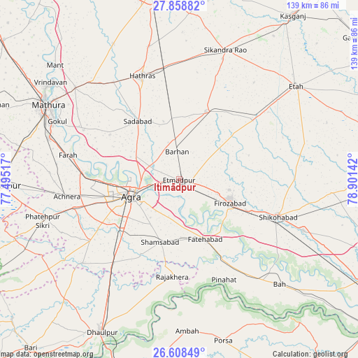
Itimādpur GPS coordinates[2]
27° 14' 7.476" North, 78° 11' 53.844" East
| Map corner | latitude | longitude |
|---|---|---|
| Upper-left | 27.85882°, | 77.49517° |
| Center: | 27.23541°, | 78.19829° |
| Lower-right: | 26.60849°, | 78.90142° |
| Map W x H: | 139×139 km | = 86.4×86.4mi |
| max Lat: | 34.9274° ⇑19.6% North |
| Itimādpur: | 27.23541° |
| min Lat: | ⇓80.4% South 8.09008° |
| min Long | Itimādpur | max Long |
| 68.82655° | 78.19829° | 96.81° |
| W 51%⇐ | ⇒49% E |
Elevation
Elevation of Itimādpur is 167 m = 548 ft, and this is 128.6 m = 422 ft below average elevation for this country.
| Max E: |
3681 m = 12077 ft | 56.6% |
| Avg. | 295.6 m = 970 ft | |
| Itimādpur | 167 m = 548 ft | |
Min E: |
1 m = 3 ft | 43.4% |
See also: India elevation on elevation.city.
Geographical zone
Itimādpur is located in North temperate zone (between Tropic of Cancer and the Arctic Circle). Distance of this Northern Tropic circle is 422.4 km =262.5 mi to South.| Distance of | km | miles | from Itimādpur |
|---|---|---|---|
| North Pole | 6978.8 | 4336.4 | to North |
| Arctic Circle | 4372.9 | 2717.2 | to North |
| Tropic Cancer | 422.4 | 262.5 | to South |
| Equator | 3028.3 | 1881.7 | to South |


Nearby cities:
15 places around Itimādpur: (largest is in red/bold)
• Agra
18.9 km =11.7 mi,  252°
252°
• Baldev
41.8 km =26 mi,  297°
297°
• Dayāl Bāgh
18.6 km =11.6 mi,  265°
265°
• Fatehābād
25.4 km =15.8 mi,  156°
156°
• Fīrozābād
21.9 km =13.6 mi,  115°
115°
• Hāthras
42.6 km =26.5 mi,  340°
340°
• Jalesar
28.4 km =17.6 mi,  21°
21°
• Kiraoli
42.3 km =26.3 mi,  255°
255°
• Pharihā
28.8 km =17.9 mi,  70°
70°
• Pināhat
42.8 km =26.6 mi, 155°
• Rājākhera
37.6 km =23.4 mi,  184°
184°
• Sadābād
27.6 km =17.1 mi,  324°
324°
• Shamsābād
25.4 km =15.8 mi,  196°
196°
• Shikohābād
40.9 km =25.4 mi,  110°
110°
• Tūndla
4.5 km =2.8 mi, 121°
Sources, notices
• [Note1] Compared only with cities in India existing in our database
• [Src1] Map data: © OpenStreetMap contributors (CC-BY-SA)
• [Src2] Other city data from geonames.org with taken over terms of usage.
• [Src3] Geographical zone / Annual Mean Temperature by Robert A. Rohde @ Wikipedia
