Wāshīm geodata
Wāshīm (Maharashtra) is a populated place; located in India in Asia/Kolkata (GMT+5.5) time zone. With population of 68,622 people, there are 629 cities with bigger population in this country. Compared to other cities in India, 64.8% of cities are located further ↑North; 61.6% of cities are located further →East and 85% of cities have lower elevation than Wāshīm. Note1


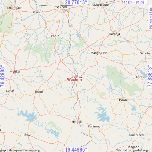
Wāshīm GPS coordinates[2]
20° 6' 40.608" North, 77° 7' 58.8" East
| Map corner | latitude | longitude |
|---|---|---|
| Upper-left | 20.77013°, | 76.42988° |
| Center: | 20.11128°, | 77.133° |
| Lower-right: | 19.44965°, | 77.83613° |
| Map W x H: | 146.8×146.8 km | = 91.2×91.2mi |
| max Lat: | 34.9274° ⇑64.8% North |
| Wāshīm: | 20.11128° |
| min Lat: | ⇓35.2% South 8.09008° |
| min Long | Wāshīm | max Long |
| 68.82655° | 77.133° | 96.81° |
| W 38.4%⇐ | ⇒61.6% E |
Elevation
Elevation of Wāshīm is 550 m = 1804 ft, and this is 254.4 m = 835 ft above average elevation for this country.
| Max E: |
3681 m = 12077 ft | 15% |
| Wāshīm | 550 m 1804 ft | |
| Avg. | 295.6 m = 970 ft | |
Min E: |
1 m = 3 ft | 85% |
See also: Wāshīm elevation on elevation.city.
Geographical zone
Wāshīm is located in North Torrid zone (between Equator and Tropic of Cancer). Distance of this Northern Tropic circle is 369.8 km =229.8 mi to North.| Distance of | km | miles | from Wāshīm |
|---|---|---|---|
| North Pole | 7770.9 | 4828.6 | to North |
| Arctic Circle | 5165 | 3209.4 | to North |
| Tropic Cancer | 369.8 | 229.8 | to North |
| Equator | 2236.2 | 1389.5 | to South |


Nearby cities:
15 places around Wāshīm: (largest is in red/bold)
• Akola
68 km =42.3 mi,  348°
348°
• Anshing
20.6 km =12.8 mi,  112°
112°
• Bālāpur
72.2 km =44.9 mi,  328°
328°
• Digras
61.1 km =38 mi,  90°
90°
• Dārwha
70.3 km =43.7 mi,  71°
71°
• Hingoli
44.1 km =27.4 mi,  178°
178°
• Jintūr
72.5 km =45 mi,  220°
220°
• Kalamnūri
52.1 km =32.4 mi,  159°
159°
• Kāranja
55.5 km =34.5 mi,  41°
41°
• Lonār
65.5 km =40.7 mi,  257°
257°
• Mangrūl Pīr
31.3 km =19.4 mi, 44°
• Mehekar
59.1 km =36.7 mi,  274°
274°
• Pusad
51.5 km =32 mi,  115°
115°
• Pātūr
43.9 km =27.3 mi, 332°
• Risod
39 km =24.2 mi,  247°
247°
Sources, notices
• [Note1] Compared only with cities in India existing in our database
• [Src1] Map data: © OpenStreetMap contributors (CC-BY-SA)
• [Src2] Other city data from geonames.org with taken over terms of usage.
• [Src3] Geographical zone / Annual Mean Temperature by Robert A. Rohde @ Wikipedia
