Umarkhed geodata
Umarkhed (Maharashtra) is a populated place; located in India in Asia/Kolkata (GMT+5.5) time zone. With population of 35,265 people, there are 1231 cities with bigger population in this country. Compared to other cities in India, 66.7% of cities are located further ↑North; 55.2% of cities are located further →East and 77.5% of cities have lower elevation than Umarkhed. Note1


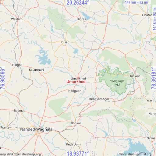
Umarkhed GPS coordinates[2]
19° 36' 5.184" North, 77° 41' 19.608" East
| Map corner | latitude | longitude |
|---|---|---|
| Upper-left | 20.26244°, | 76.98566° |
| Center: | 19.60144°, | 77.68878° |
| Lower-right: | 18.93771°, | 78.39191° |
| Map W x H: | 147.3×147.3 km | = 91.5×91.5mi |
| max Lat: | 34.9274° ⇑66.7% North |
| Umarkhed: | 19.60144° |
| min Lat: | ⇓33.3% South 8.09008° |
| min Long | Umarkhed | max Long |
| 68.82655° | 77.68878° | 96.81° |
| W 44.8%⇐ | ⇒55.2% E |
Elevation
Elevation of Umarkhed is 424 m = 1391 ft, and this is 128.4 m = 421 ft above average elevation for this country.
| Max E: |
3681 m = 12077 ft | 22.5% |
| Umarkhed | 424 m 1391 ft | |
| Avg. | 295.6 m = 970 ft | |
Min E: |
1 m = 3 ft | 77.5% |
See also: India elevation on elevation.city.
Geographical zone
Umarkhed is located in North Torrid zone (between Equator and Tropic of Cancer). Distance of this Northern Tropic circle is 426.4 km =265 mi to North.| Distance of | km | miles | from Umarkhed |
|---|---|---|---|
| North Pole | 7827.6 | 4863.8 | to North |
| Arctic Circle | 5221.7 | 3244.6 | to North |
| Tropic Cancer | 426.4 | 265 | to North |
| Equator | 2179.5 | 1354.3 | to South |


Nearby cities:
15 places around Umarkhed: (largest is in red/bold)
• Anshing
62.6 km =38.9 mi,  321°
321°
• Basmat
63.4 km =39.4 mi,  241°
241°
• Bhaisa
61.5 km =38.2 mi,  152°
152°
• Dharmābād
80.8 km =50.2 mi,  167°
167°
• Digras
55.9 km =34.7 mi,  3°
3°
• Dārwha
79.3 km =49.3 mi,  6°
6°
• Hadgāon
12.2 km =7.6 mi,  195°
195°
• Hingoli
58.6 km =36.4 mi,  282°
282°
• Kalamnūri
40.3 km =25 mi, 281°
• Kinwat
53.5 km =33.2 mi,  87°
87°
• Mudkhed
53.2 km =33.1 mi, 201°
• Nanded
62.8 km =39 mi,  218°
218°
• Pusad
36.5 km =22.7 mi,  341°
341°
• Pūrna
83.8 km =52.1 mi, 236°
• Wāshīm
81.2 km =50.5 mi,  314°
314°
Sources, notices
• [Note1] Compared only with cities in India existing in our database
• [Src1] Map data: © OpenStreetMap contributors (CC-BY-SA)
• [Src2] Other city data from geonames.org with taken over terms of usage.
• [Src3] Geographical zone / Annual Mean Temperature by Robert A. Rohde @ Wikipedia
