Chhota Udepur geodata
Chhota Udepur (Gujarat) is a seat of a second-order administrative division; located in India in Asia/Kolkata (GMT+5.5) time zone. With population of 24,517 people, there are 1737 cities with bigger population in this country. Compared to other cities in India, 54.4% of cities are located further ↑North; 89.3% of cities are located further →East and 59.6% of cities have higher elevation than Chhota Udepur. Note1


Chhota Udepur GPS coordinates[2]
22° 18' 14.436" North, 74° 0' 56.88" East
| Map corner | latitude | longitude |
|---|---|---|
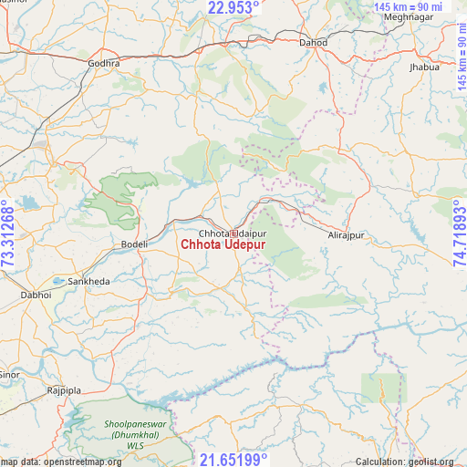
| Upper-left | 22.953°, | 73.31268° |
| Center: | 22.30401°, | 74.0158° |
| Lower-right: | 21.65199°, | 74.71893° |
| Map W x H: | 144.7×144.7 km | = 89.9×89.9mi |
| max Lat: | 34.9274° ⇑54.4% North |
| Chhota Udepur: | 22.30401° |
| min Lat: | ⇓45.6% South 8.09008° |
| min Long | Chhota Udepur | max Long |
| 68.82655° | 74.0158° | 96.81° |
| W 10.7%⇐ | ⇒89.3% E |
Elevation
Elevation of Chhota Udepur is 150 m = 492 ft, and this is 145.6 m = 478 ft below average elevation for this country.
| Max E: |
3681 m = 12077 ft | 59.6% |
| Avg. | 295.6 m = 970 ft | |
| Chhota Udepur | 150 m = 492 ft | |
Min E: |
1 m = 3 ft | 40.4% |
See also: India elevation on elevation.city.
Geographical zone
Chhota Udepur is located in North Torrid zone (between Equator and Tropic of Cancer). Distance of this Northern Tropic circle is 125.9 km =78.2 mi to North.| Distance of | km | miles | from Chhota Udepur |
|---|---|---|---|
| North Pole | 7527.1 | 4677.1 | to North |
| Arctic Circle | 4921.2 | 3057.9 | to North |
| Tropic Cancer | 125.9 | 78.2 | to North |
| Equator | 2480 | 1541 | to South |


Nearby cities:
15 places around Chhota Udepur: (largest is in red/bold)
• Bhābhra
40.8 km =25.4 mi,  51°
51°
• Dabhoi
61.4 km =38.2 mi,  257°
257°
• Devgadh Bāriya
45.9 km =28.5 mi,  346°
346°
• Dohad
63.9 km =39.7 mi,  23°
23°
• Hālol
60.1 km =37.3 mi,  291°
291°
• Jetpur
18.5 km =11.5 mi,  284°
284°
• Jobat
58.2 km =36.2 mi,  77°
77°
• Kawānt
23.8 km =14.8 mi,  171°
171°
• Kālol
66.1 km =41.1 mi,  300°
300°
• Rajpur
35 km =21.7 mi,  90°
90°
• Rānāpur
64.4 km =40 mi, 53°
• Sankheda
47.4 km =29.5 mi,  251°
251°
• Shivrājpur
43.9 km =27.3 mi, 287°
• Vejalpur
63.3 km =39.3 mi,  312°
312°
• Vāghodia
63.3 km =39.3 mi,  270°
270°
Sources, notices
• [Note1] Compared only with cities in India existing in our database
• [Src1] Map data: © OpenStreetMap contributors (CC-BY-SA)
• [Src2] Other city data from geonames.org with taken over terms of usage.
• [Src3] Geographical zone / Annual Mean Temperature by Robert A. Rohde @ Wikipedia
