Sambhal geodata
Sambhal (Uttar Pradesh) is a seat of a second-order administrative division; located in India in Asia/Kolkata (GMT+5.5) time zone. With population of 196,109 people, there are 217 cities with bigger population in this country. Compared to other cities in India, 87.1% of cities are located further ↓South; 54.8% of cities are located further ←West and 50.3% of cities have lower elevation than Sambhal. Note1


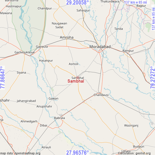
Sambhal GPS coordinates[2]
28° 35' 5.928" North, 78° 34' 10.524" East
| Map corner | latitude | longitude |
|---|---|---|
| Upper-left | 29.20058°, | 77.86647° |
| Center: | 28.58498°, | 78.56959° |
| Lower-right: | 27.96576°, | 79.27272° |
| Map W x H: | 137.3×137.3 km | = 85.3×85.3mi |
| max Lat: | 34.9274° ⇑12.9% North |
| Sambhal: | 28.58498° |
| min Lat: | ⇓87.1% South 8.09008° |
| min Long | Sambhal | max Long |
| 68.82655° | 78.56959° | 96.81° |
| W 54.8%⇐ | ⇒45.2% E |
Elevation
Elevation of Sambhal is 203 m = 666 ft, and this is 92.6 m = 304 ft below average elevation for this country.
| Max E: |
3681 m = 12077 ft | 49.7% |
| Avg. | 295.6 m = 970 ft | |
| Sambhal | 203 m = 666 ft | |
Min E: |
1 m = 3 ft | 50.3% |
See also: Sambhal elevation on elevation.city.
Geographical zone
Sambhal is located in North temperate zone (between Tropic of Cancer and the Arctic Circle). Distance of this Northern Tropic circle is 572.4 km =355.7 mi to South.| Distance of | km | miles | from Sambhal |
|---|---|---|---|
| North Pole | 6828.7 | 4243.2 | to North |
| Arctic Circle | 4222.8 | 2623.9 | to North |
| Tropic Cancer | 572.4 | 355.7 | to South |
| Equator | 3178.4 | 1975 | to South |


Nearby cities:
15 places around Sambhal: (largest is in red/bold)
• Amroha
36.7 km =22.8 mi,  344°
344°
• Anūpshahr
38.8 km =24.1 mi,  229°
229°
• Babrāla
39.1 km =24.3 mi,  204°
204°
• Bahjoi
21.8 km =13.5 mi,  165°
165°
• Bilāri
23.2 km =14.4 mi,  79°
79°
• Chanduasi
25.6 km =15.9 mi,  125°
125°
• Gawān
28.1 km =17.5 mi, 229°
• Gunnaur
40.4 km =25.1 mi, 198°
• Hasanpur
31.8 km =19.8 mi,  298°
298°
• Islāmnagar
32.3 km =20.1 mi,  151°
151°
• Kundarkhi
23.7 km =14.7 mi,  62°
62°
• Morādābād
34.7 km =21.6 mi,  35°
35°
• Narauli
18 km =11.2 mi, 127°
• Shāhābād
43 km =26.7 mi,  92°
92°
• Sirsi
9.4 km =5.8 mi,  49°
49°
Sources, notices
• [Note1] Compared only with cities in India existing in our database
• [Src1] Map data: © OpenStreetMap contributors (CC-BY-SA)
• [Src2] Other city data from geonames.org with taken over terms of usage.
• [Src3] Geographical zone / Annual Mean Temperature by Robert A. Rohde @ Wikipedia
