Gunnaur geodata
Gunnaur (Uttar Pradesh) is a populated place; located in India in Asia/Kolkata (GMT+5.5) time zone. With population of 20,980 people, there are 1971 cities with bigger population in this country. Compared to other cities in India, 85.6% of cities are located further ↓South; 53.5% of cities are located further ←West and 53.5% of cities have higher elevation than Gunnaur. Note1


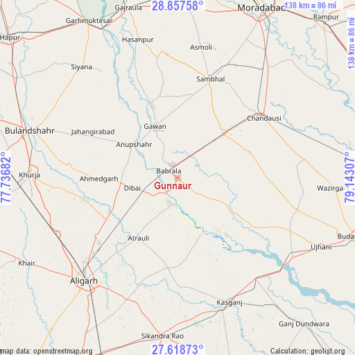
Gunnaur GPS coordinates[2]
28° 14' 23.82" North, 78° 26' 23.784" East
| Map corner | latitude | longitude |
|---|---|---|
| Upper-left | 28.85758°, | 77.73682° |
| Center: | 28.23995°, | 78.43994° |
| Lower-right: | 27.61873°, | 79.14307° |
| Map W x H: | 137.7×137.7 km | = 85.6×85.6mi |
| max Lat: | 34.9274° ⇑14.4% North |
| Gunnaur: | 28.23995° |
| min Lat: | ⇓85.6% South 8.09008° |
| min Long | Gunnaur | max Long |
| 68.82655° | 78.43994° | 96.81° |
| W 53.5%⇐ | ⇒46.5% E |
Elevation
Elevation of Gunnaur is 182 m = 597 ft, and this is 113.6 m = 373 ft below average elevation for this country.
| Max E: |
3681 m = 12077 ft | 53.5% |
| Avg. | 295.6 m = 970 ft | |
| Gunnaur | 182 m = 597 ft | |
Min E: |
1 m = 3 ft | 46.5% |
See also: India elevation on elevation.city.
Geographical zone
Gunnaur is located in North temperate zone (between Tropic of Cancer and the Arctic Circle). Distance of this Northern Tropic circle is 534.1 km =331.9 mi to South.| Distance of | km | miles | from Gunnaur |
|---|---|---|---|
| North Pole | 6867.1 | 4267 | to North |
| Arctic Circle | 4261.2 | 2647.8 | to North |
| Tropic Cancer | 534.1 | 331.9 | to South |
| Equator | 3140 | 1951.1 | to South |


Nearby cities:
15 places around Gunnaur: (largest is in red/bold)
• Anūpshahr
21.2 km =13.2 mi,  308°
308°
• Atraulī
27.8 km =17.3 mi,  212°
212°
• Babrāla
4.3 km =2.7 mi, 308°
• Bahjoi
25.1 km =15.6 mi,  46°
46°
• Chanduasi
41 km =25.5 mi, 54°
• Chharra
35.3 km =21.9 mi,  186°
186°
• Dibai
17.8 km =11.1 mi,  258°
258°
• Gawān
21.8 km =13.5 mi,  336°
336°
• Islāmnagar
29.6 km =18.4 mi,  70°
70°
• Jahāngīrābād
37.5 km =23.3 mi,  299°
299°
• Narauli
38.3 km =23.8 mi,  44°
44°
• Naraura
6.7 km =4.2 mi,  230°
230°
• Pahāsu
37.6 km =23.4 mi, 258°
• Sahaswān
35.7 km =22.2 mi,  121°
121°
• Sambhal
40.4 km =25.1 mi,  18°
18°
Sources, notices
• [Note1] Compared only with cities in India existing in our database
• [Src1] Map data: © OpenStreetMap contributors (CC-BY-SA)
• [Src2] Other city data from geonames.org with taken over terms of usage.
• [Src3] Geographical zone / Annual Mean Temperature by Robert A. Rohde @ Wikipedia
