Sirsi geodata
Sirsi (Uttar Pradesh) is a populated place; located in India in Asia/Kolkata (GMT+5.5) time zone. With population of 22,549 people, there are 1873 cities with bigger population in this country. Compared to other cities in India, 87.5% of cities are located further ↓South; 55.6% of cities are located further ←West and 50.1% of cities have lower elevation than Sirsi. Note1


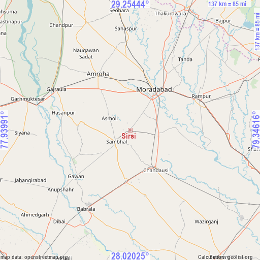
Sirsi GPS coordinates[2]
28° 38' 20.976" North, 78° 38' 34.908" East
| Map corner | latitude | longitude |
|---|---|---|
| Upper-left | 29.25444°, | 77.93991° |
| Center: | 28.63916°, | 78.64303° |
| Lower-right: | 28.02025°, | 79.34616° |
| Map W x H: | 137.2×137.2 km | = 85.3×85.3mi |
| max Lat: | 34.9274° ⇑12.5% North |
| Sirsi: | 28.63916° |
| min Lat: | ⇓87.5% South 8.09008° |
| min Long | Sirsi | max Long |
| 68.82655° | 78.64303° | 96.81° |
| W 55.6%⇐ | ⇒44.4% E |
Elevation
Elevation of Sirsi is 202 m = 663 ft, and this is 93.6 m = 307 ft below average elevation for this country.
| Max E: |
3681 m = 12077 ft | 49.9% |
| Avg. | 295.6 m = 970 ft | |
| Sirsi | 202 m = 663 ft | |
Min E: |
1 m = 3 ft | 50.1% |
See also: India elevation on elevation.city.
Geographical zone
Sirsi is located in North temperate zone (between Tropic of Cancer and the Arctic Circle). Distance of this Northern Tropic circle is 578.5 km =359.5 mi to South.| Distance of | km | miles | from Sirsi |
|---|---|---|---|
| North Pole | 6822.7 | 4239.4 | to North |
| Arctic Circle | 4216.8 | 2620.2 | to North |
| Tropic Cancer | 578.5 | 359.5 | to South |
| Equator | 3184.4 | 1978.7 | to South |


Nearby cities:
15 places around Sirsi: (largest is in red/bold)
• Amroha
33.9 km =21.1 mi,  330°
330°
• Bahjoi
27.2 km =16.9 mi,  183°
183°
• Bilāri
15.8 km =9.8 mi,  97°
97°
• Chanduasi
24.9 km =15.5 mi,  146°
146°
• Gajraula
45.5 km =28.3 mi,  300°
300°
• Gawān
37.5 km =23.3 mi,  229°
229°
• Hasanpur
36.2 km =22.5 mi,  284°
284°
• Islāmnagar
35.4 km =22 mi,  166°
166°
• Kundarkhi
14.7 km =9.1 mi,  70°
70°
• Morādābād
25.8 km =16 mi,  30°
30°
• Narauli
18.5 km =11.5 mi,  157°
157°
• Rāmpur
42 km =26.1 mi,  63°
63°
• Sambhal
9.4 km =5.8 mi, 229°
• Sarauli
46.7 km =29 mi,  110°
110°
• Shāhābād
36.7 km =22.8 mi, 102°
Sources, notices
• [Note1] Compared only with cities in India existing in our database
• [Src1] Map data: © OpenStreetMap contributors (CC-BY-SA)
• [Src2] Other city data from geonames.org with taken over terms of usage.
• [Src3] Geographical zone / Annual Mean Temperature by Robert A. Rohde @ Wikipedia
