Khunti geodata
Khunti (Jharkhand) is a populated place; located in India in Asia/Kolkata (GMT+5.5) time zone. With population of 31,366 people, there are 1383 cities with bigger population in this country. Compared to other cities in India, 52.2% of cities are located further ↓South; 85% of cities are located further ←West and 90.9% of cities have lower elevation than Khunti. Note1


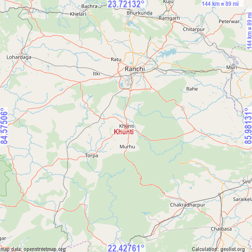
Khunti GPS coordinates[2]
23° 4' 33.672" North, 85° 16' 41.448" East
| Map corner | latitude | longitude |
|---|---|---|
| Upper-left | 23.72132°, | 84.57506° |
| Center: | 23.07602°, | 85.27818° |
| Lower-right: | 22.42761°, | 85.98131° |
| Map W x H: | 143.8×143.8 km | = 89.4×89.4mi |
| max Lat: | 34.9274° ⇑47.8% North |
| Khunti: | 23.07602° |
| min Lat: | ⇓52.2% South 8.09008° |
| min Long | Khunti | max Long |
| 68.82655° | 85.27818° | 96.81° |
| W 85%⇐ | ⇒15% E |
Elevation
Elevation of Khunti is 650 m = 2133 ft, and this is 354.4 m = 1163 ft above average elevation for this country.
| Max E: |
3681 m = 12077 ft | 9.1% |
| Khunti | 650 m 2133 ft | |
| Avg. | 295.6 m = 970 ft | |
Min E: |
1 m = 3 ft | 90.9% |
See also: India elevation on elevation.city.
Geographical zone
Khunti is located in North Torrid zone (between Equator and Tropic of Cancer). Distance of this Northern Tropic circle is 40.1 km =24.9 mi to North.| Distance of | km | miles | from Khunti |
|---|---|---|---|
| North Pole | 7441.2 | 4623.7 | to North |
| Arctic Circle | 4835.4 | 3004.6 | to North |
| Tropic Cancer | 40.1 | 24.9 | to North |
| Equator | 2565.8 | 1594.3 | to South |


Nearby cities:
15 places around Khunti: (largest is in red/bold)
• Barkā Kānā
63.6 km =39.5 mi,  17°
17°
• Būndu
33.3 km =20.7 mi,  73°
73°
• Chakradharpur
57.2 km =35.5 mi,  141°
141°
• Gumlā
75.2 km =46.7 mi,  267°
267°
• Jhalidā
78.3 km =48.7 mi, 65°
• Kharsāwān
64.9 km =40.3 mi,  119°
119°
• Kuju
76 km =47.2 mi, 18°
• Kānke
40.1 km =24.9 mi,  6°
6°
• Lohārdagā
72.9 km =45.3 mi,  303°
303°
• Manoharpur
78.5 km =48.8 mi,  186°
186°
• Muri
68.1 km =42.3 mi,  61°
61°
• Ranchi
29.9 km =18.6 mi, 6°
• Rāmgarh
66.4 km =41.3 mi, 21°
• Rāy
71.4 km =44.4 mi,  341°
341°
• Sini
75.2 km =46.7 mi,  114°
114°
Sources, notices
• [Note1] Compared only with cities in India existing in our database
• [Src1] Map data: © OpenStreetMap contributors (CC-BY-SA)
• [Src2] Other city data from geonames.org with taken over terms of usage.
• [Src3] Geographical zone / Annual Mean Temperature by Robert A. Rohde @ Wikipedia
