Kalyandurg geodata
Kalyandurg (Andhra Pradesh) is a populated place; located in India in Asia/Kolkata (GMT+5.5) time zone. With population of 29,272 people, there are 1480 cities with bigger population in this country. Compared to other cities in India, 82.3% of cities are located further ↑North; 61.9% of cities are located further →East and 88% of cities have lower elevation than Kalyandurg. Note1


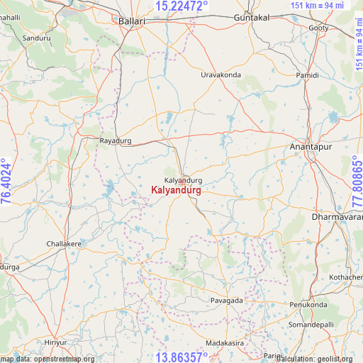
Kalyandurg GPS coordinates[2]
14° 32' 42.684" North, 77° 6' 19.872" East
| Map corner | latitude | longitude |
|---|---|---|
| Upper-left | 15.22472°, | 76.4024° |
| Center: | 14.54519°, | 77.10552° |
| Lower-right: | 13.86357°, | 77.80865° |
| Map W x H: | 151.3×151.3 km | = 94×94mi |
| max Lat: | 34.9274° ⇑82.3% North |
| Kalyandurg: | 14.54519° |
| min Lat: | ⇓17.7% South 8.09008° |
| min Long | Kalyandurg | max Long |
| 68.82655° | 77.10552° | 96.81° |
| W 38.1%⇐ | ⇒61.9% E |
Elevation
Elevation of Kalyandurg is 592 m = 1942 ft, and this is 296.4 m = 972 ft above average elevation for this country.
| Max E: |
3681 m = 12077 ft | 12% |
| Kalyandurg | 592 m 1942 ft | |
| Avg. | 295.6 m = 970 ft | |
Min E: |
1 m = 3 ft | 88% |
See also: India elevation on elevation.city.
Geographical zone
Kalyandurg is located in North Torrid zone (between Equator and Tropic of Cancer). Distance of this Northern Tropic circle is 988.6 km =614.3 mi to North.| Distance of | km | miles | from Kalyandurg |
|---|---|---|---|
| North Pole | 8389.8 | 5213.2 | to North |
| Arctic Circle | 5783.9 | 3593.9 | to North |
| Tropic Cancer | 988.6 | 614.3 | to North |
| Equator | 1617.3 | 1004.9 | to South |


Nearby cities:
15 places around Kalyandurg: (largest is in red/bold)
• Anantapur
56.1 km =34.9 mi,  74°
74°
• Bellary
69.2 km =43 mi,  343°
343°
• Challakere
55 km =34.2 mi,  242°
242°
• Chitradurga
84 km =52.2 mi, 244°
• Dharmavaram
67.8 km =42.1 mi,  102°
102°
• Guntakal Junction
74.9 km =46.5 mi,  21°
21°
• Hiriyūr
85 km =52.8 mi,  218°
218°
• Hosakote
30.7 km =19.1 mi,  167°
167°
• Jagalūr
82.5 km =51.3 mi,  268°
268°
• Penukonda
73.6 km =45.7 mi,  134°
134°
• Puttaparthi
87 km =54.1 mi,  119°
119°
• Pāvugada
53 km =32.9 mi,  159°
159°
• Rāyadrug
32.2 km =20 mi,  302°
302°
• Sandūr
85 km =52.8 mi,  315°
315°
• Uravakonda
47.1 km =29.3 mi, 19°
Sources, notices
• [Note1] Compared only with cities in India existing in our database
• [Src1] Map data: © OpenStreetMap contributors (CC-BY-SA)
• [Src2] Other city data from geonames.org with taken over terms of usage.
• [Src3] Geographical zone / Annual Mean Temperature by Robert A. Rohde @ Wikipedia
