Rāyadrug geodata
Rāyadrug (Andhra Pradesh) is a populated place; located in India in Asia/Kolkata (GMT+5.5) time zone. With population of 59,968 people, there are 734 cities with bigger population in this country. Compared to other cities in India, 82.1% of cities are located further ↑North; 64.7% of cities are located further →East and 85.2% of cities have lower elevation than Rāyadrug. Note1


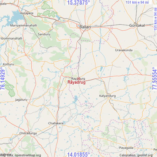
Rāyadrug GPS coordinates[2]
14° 41' 58.956" North, 76° 51' 8.676" East
| Map corner | latitude | longitude |
|---|---|---|
| Upper-left | 15.37875°, | 76.14929° |
| Center: | 14.69971°, | 76.85241° |
| Lower-right: | 14.01855°, | 77.55554° |
| Map W x H: | 151.2×151.2 km | = 94×94mi |
| max Lat: | 34.9274° ⇑82.1% North |
| Rāyadrug: | 14.69971° |
| min Lat: | ⇓17.9% South 8.09008° |
| min Long | Rāyadrug | max Long |
| 68.82655° | 76.85241° | 96.81° |
| W 35.3%⇐ | ⇒64.7% E |
Elevation
Elevation of Rāyadrug is 553 m = 1814 ft, and this is 257.4 m = 844 ft above average elevation for this country.
| Max E: |
3681 m = 12077 ft | 14.8% |
| Rāyadrug | 553 m 1814 ft | |
| Avg. | 295.6 m = 970 ft | |
Min E: |
1 m = 3 ft | 85.2% |
See also: Rāyadrug elevation on elevation.city.
Geographical zone
Rāyadrug is located in North Torrid zone (between Equator and Tropic of Cancer). Distance of this Northern Tropic circle is 971.5 km =603.7 mi to North.| Distance of | km | miles | from Rāyadrug |
|---|---|---|---|
| North Pole | 8372.6 | 5202.5 | to North |
| Arctic Circle | 5766.7 | 3583.3 | to North |
| Tropic Cancer | 971.5 | 603.7 | to North |
| Equator | 1634.5 | 1015.6 | to South |


Nearby cities:
15 places around Rāyadrug: (largest is in red/bold)
• Anantapur
81.3 km =50.5 mi,  91°
91°
• Bellary
49.8 km =30.9 mi,  8°
8°
• Challakere
47.6 km =29.6 mi,  206°
206°
• Chitradurga
72 km =44.7 mi,  222°
222°
• Guntakal Junction
75.8 km =47.1 mi,  46°
46°
• Hampi
82.3 km =51.1 mi,  329°
329°
• Hosakote
58.1 km =36.1 mi,  144°
144°
• Hospet
80.7 km =50.1 mi,  321°
321°
• Jagalūr
58.7 km =36.5 mi,  250°
250°
• Kalyandurg
32.2 km =20 mi,  122°
122°
• Kottūru
69.4 km =43.1 mi,  281°
281°
• Kūdligi
55.2 km =34.3 mi,  294°
294°
• Pāvugada
81.1 km =50.4 mi,  145°
145°
• Sandūr
54.1 km =33.6 mi, 322°
• Uravakonda
51.1 km =31.8 mi,  57°
57°
Sources, notices
• [Note1] Compared only with cities in India existing in our database
• [Src1] Map data: © OpenStreetMap contributors (CC-BY-SA)
• [Src2] Other city data from geonames.org with taken over terms of usage.
• [Src3] Geographical zone / Annual Mean Temperature by Robert A. Rohde @ Wikipedia
