Uravakonda geodata
Uravakonda (Andhra Pradesh) is a populated place; located in India in Asia/Kolkata (GMT+5.5) time zone. With population of 33,495 people, there are 1298 cities with bigger population in this country. Compared to other cities in India, 81.7% of cities are located further ↑North; 60.5% of cities are located further →East and 80.9% of cities have lower elevation than Uravakonda. Note1


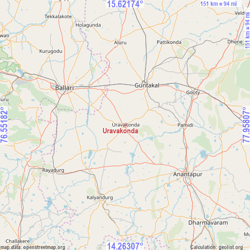
Uravakonda GPS coordinates[2]
14° 56' 36.528" North, 77° 15' 17.784" East
| Map corner | latitude | longitude |
|---|---|---|
| Upper-left | 15.62174°, | 76.55182° |
| Center: | 14.94348°, | 77.25494° |
| Lower-right: | 14.26307°, | 77.95807° |
| Map W x H: | 151.1×151.1 km | = 93.9×93.9mi |
| max Lat: | 34.9274° ⇑81.7% North |
| Uravakonda: | 14.94348° |
| min Lat: | ⇓18.3% South 8.09008° |
| min Long | Uravakonda | max Long |
| 68.82655° | 77.25494° | 96.81° |
| W 39.5%⇐ | ⇒60.5% E |
Elevation
Elevation of Uravakonda is 473 m = 1552 ft, and this is 177.4 m = 582 ft above average elevation for this country.
| Max E: |
3681 m = 12077 ft | 19.1% |
| Uravakonda | 473 m 1552 ft | |
| Avg. | 295.6 m = 970 ft | |
Min E: |
1 m = 3 ft | 80.9% |
See also: India elevation on elevation.city.
Geographical zone
Uravakonda is located in North Torrid zone (between Equator and Tropic of Cancer). Distance of this Northern Tropic circle is 944.4 km =586.8 mi to North.| Distance of | km | miles | from Uravakonda |
|---|---|---|---|
| North Pole | 8345.5 | 5185.7 | to North |
| Arctic Circle | 5739.6 | 3566.4 | to North |
| Tropic Cancer | 944.4 | 586.8 | to North |
| Equator | 1661.6 | 1032.5 | to South |


Nearby cities:
15 places around Uravakonda: (largest is in red/bold)
• Anantapur
48.1 km =29.9 mi,  127°
127°
• Bellary
41.8 km =26 mi,  301°
301°
• Dharmavaram
77.2 km =48 mi,  139°
139°
• Dhone
83.1 km =51.6 mi,  52°
52°
• Guntakal Junction
27.8 km =17.3 mi,  24°
24°
• Hosakote
74.8 km =46.5 mi,  187°
187°
• Kalyandurg
47.1 km =29.3 mi,  199°
199°
• Kampli
87.1 km =54.1 mi,  306°
306°
• Rāmāpuram
76 km =47.2 mi,  59°
59°
• Rāyadrug
51.1 km =31.8 mi,  237°
237°
• Sandūr
77.7 km =48.3 mi,  281°
281°
• Siruguppa
85.7 km =53.3 mi,  332°
332°
• Tekkalakote
77.2 km =48 mi, 328°
• Tādpatri
81.2 km =50.5 mi,  92°
92°
• Ādoni
76.1 km =47.3 mi,  1°
1°
Sources, notices
• [Note1] Compared only with cities in India existing in our database
• [Src1] Map data: © OpenStreetMap contributors (CC-BY-SA)
• [Src2] Other city data from geonames.org with taken over terms of usage.
• [Src3] Geographical zone / Annual Mean Temperature by Robert A. Rohde @ Wikipedia
