Una geodata
Una (Himachal Pradesh) is a populated place; located in India in Asia/Kolkata (GMT+5.5) time zone. With population of 17,569 people, there are 2229 cities with bigger population in this country. Compared to other cities in India, 96.9% of cities are located further ↓South; 71% of cities are located further →East and 75.7% of cities have lower elevation than Una. Note1


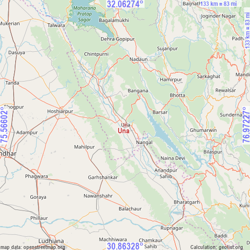
Una GPS coordinates[2]
31° 27' 53.748" North, 76° 16' 8.904" East
| Map corner | latitude | longitude |
|---|---|---|
| Upper-left | 32.06274°, | 75.56602° |
| Center: | 31.46493°, | 76.26914° |
| Lower-right: | 30.86328°, | 76.97227° |
| Map W x H: | 133.4×133.4 km | = 82.9×82.9mi |
| max Lat: | 34.9274° ⇑3.1% North |
| Una: | 31.46493° |
| min Lat: | ⇓96.9% South 8.09008° |
| min Long | Una | max Long |
| 68.82655° | 76.26914° | 96.81° |
| W 29%⇐ | ⇒71% E |
Elevation
Elevation of Una is 395 m = 1296 ft, and this is 99.4 m = 326 ft above average elevation for this country.
| Max E: |
3681 m = 12077 ft | 24.3% |
| Una | 395 m 1296 ft | |
| Avg. | 295.6 m = 970 ft | |
Min E: |
1 m = 3 ft | 75.7% |
See also: India elevation on elevation.city.
Geographical zone
Una is located in North temperate zone (between Tropic of Cancer and the Arctic Circle). Distance of this Northern Tropic circle is 892.7 km =554.7 mi to South.| Distance of | km | miles | from Una |
|---|---|---|---|
| North Pole | 6508.5 | 4044.2 | to North |
| Arctic Circle | 3902.6 | 2425 | to North |
| Tropic Cancer | 892.7 | 554.7 | to South |
| Equator | 3498.6 | 2173.9 | to South |


Nearby cities:
15 places around Una: (largest is in red/bold)
• Anandpur
33.5 km =20.8 mi,  138°
138°
• Banga
40.3 km =25 mi,  220°
220°
• Bālāchor
45.1 km =28 mi,  176°
176°
• Daulatpur
44.6 km =27.7 mi,  323°
323°
• Gagret
29.2 km =18.1 mi, 317°
• Garhshankar
30.3 km =18.8 mi,  203°
203°
• Ghumārwīn
42.4 km =26.3 mi,  93°
93°
• Hamīrpur
34.4 km =21.4 mi,  44°
44°
• Hariāna
44.9 km =27.9 mi,  294°
294°
• Hoshiārpur
34.7 km =21.6 mi,  283°
283°
• Nangal
13.1 km =8.1 mi,  129°
129°
• Nawanshahr
40.5 km =25.2 mi, 201°
• Nādaun
36.1 km =22.4 mi,  11°
11°
• Nūrpur Kalān
38.9 km =24.2 mi,  148°
148°
• Santokhgarh
13.4 km =8.3 mi,  159°
159°
Sources, notices
• [Note1] Compared only with cities in India existing in our database
• [Src1] Map data: © OpenStreetMap contributors (CC-BY-SA)
• [Src2] Other city data from geonames.org with taken over terms of usage.
• [Src3] Geographical zone / Annual Mean Temperature by Robert A. Rohde @ Wikipedia
