Santokhgarh geodata
Santokhgarh (Himachal Pradesh) is a populated place; located in India in Asia/Kolkata (GMT+5.5) time zone. With population of 8,877 people, there are 3050 cities with bigger population in this country. Compared to other cities in India, 96.6% of cities are located further ↓South; 70.4% of cities are located further →East and 71.9% of cities have lower elevation than Santokhgarh. Note1


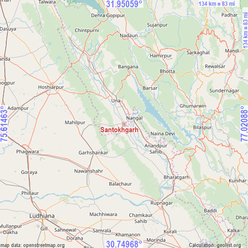
Santokhgarh GPS coordinates[2]
31° 21' 7.38" North, 76° 19' 3.9" East
| Map corner | latitude | longitude |
|---|---|---|
| Upper-left | 31.95059°, | 75.61463° |
| Center: | 31.35205°, | 76.31775° |
| Lower-right: | 30.74968°, | 77.02088° |
| Map W x H: | 133.5×133.5 km | = 83×83mi |
| max Lat: | 34.9274° ⇑3.4% North |
| Santokhgarh: | 31.35205° |
| min Lat: | ⇓96.6% South 8.09008° |
| min Long | Santokhgarh | max Long |
| 68.82655° | 76.31775° | 96.81° |
| W 29.6%⇐ | ⇒70.4% E |
Elevation
Elevation of Santokhgarh is 348 m = 1142 ft, and this is 52.4 m = 172 ft above average elevation for this country.
| Max E: |
3681 m = 12077 ft | 28.1% |
| Santokhgarh | 348 m 1142 ft | |
| Avg. | 295.6 m = 970 ft | |
Min E: |
1 m = 3 ft | 71.9% |
See also: India elevation on elevation.city.
Geographical zone
Santokhgarh is located in North temperate zone (between Tropic of Cancer and the Arctic Circle). Distance of this Northern Tropic circle is 880.1 km =546.9 mi to South.| Distance of | km | miles | from Santokhgarh |
|---|---|---|---|
| North Pole | 6521 | 4052 | to North |
| Arctic Circle | 3915.2 | 2432.8 | to North |
| Tropic Cancer | 880.1 | 546.9 | to South |
| Equator | 3486 | 2166.1 | to South |


Nearby cities:
15 places around Santokhgarh: (largest is in red/bold)
• Anandpur
21.6 km =13.4 mi,  125°
125°
• Banga
35.6 km =22.1 mi,  239°
239°
• Bilaspur
41.7 km =25.9 mi,  93°
93°
• Bālāchor
32.4 km =20.1 mi,  182°
182°
• Gagret
41.8 km =26 mi,  324°
324°
• Garhshankar
22.6 km =14 mi,  227°
227°
• Ghumārwīn
39 km =24.2 mi,  75°
75°
• Hamīrpur
41.8 km =26 mi,  28°
28°
• Hoshiārpur
43.6 km =27.1 mi,  298°
298°
• Nangal
6.9 km =4.3 mi,  52°
52°
• Nawanshahr
31.7 km =19.7 mi,  217°
217°
• Nūrpur Kalān
25.9 km =16.1 mi,  142°
142°
• Ropar
47 km =29.2 mi,  154°
154°
• Rāhon
38.3 km =23.8 mi,  209°
209°
• Una
13.4 km =8.3 mi,  339°
339°
Sources, notices
• [Note1] Compared only with cities in India existing in our database
• [Src1] Map data: © OpenStreetMap contributors (CC-BY-SA)
• [Src2] Other city data from geonames.org with taken over terms of usage.
• [Src3] Geographical zone / Annual Mean Temperature by Robert A. Rohde @ Wikipedia
