Puttaparthi geodata
Puttaparthi (Andhra Pradesh) is a populated place; located in India in Asia/Kolkata (GMT+5.5) time zone. With population of 9,000 people, there are 3034 cities with bigger population in this country. Compared to other cities in India, 83% of cities are located further ↑North; 53.4% of cities are located further →East and 80.4% of cities have lower elevation than Puttaparthi. Note1


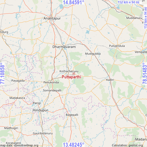
Puttaparthi GPS coordinates[2]
14° 9' 54.72" North, 77° 48' 42.12" East
| Map corner | latitude | longitude |
|---|---|---|
| Upper-left | 14.84591°, | 77.10858° |
| Center: | 14.1652°, | 77.8117° |
| Lower-right: | 13.48245°, | 78.51483° |
| Map W x H: | 151.6×151.6 km | = 94.2×94.2mi |
| max Lat: | 34.9274° ⇑83% North |
| Puttaparthi: | 14.1652° |
| min Lat: | ⇓17% South 8.09008° |
| min Long | Puttaparthi | max Long |
| 68.82655° | 77.8117° | 96.81° |
| W 46.6%⇐ | ⇒53.4% E |
Elevation
Elevation of Puttaparthi is 466 m = 1529 ft, and this is 170.4 m = 559 ft above average elevation for this country.
| Max E: |
3681 m = 12077 ft | 19.6% |
| Puttaparthi | 466 m 1529 ft | |
| Avg. | 295.6 m = 970 ft | |
Min E: |
1 m = 3 ft | 80.4% |
See also: India elevation on elevation.city.
Geographical zone
Puttaparthi is located in North Torrid zone (between Equator and Tropic of Cancer). Distance of this Northern Tropic circle is 1030.9 km =640.6 mi to North.| Distance of | km | miles | from Puttaparthi |
|---|---|---|---|
| North Pole | 8432 | 5239.4 | to North |
| Arctic Circle | 5826.2 | 3620.2 | to North |
| Tropic Cancer | 1030.9 | 640.6 | to North |
| Equator | 1575 | 978.7 | to South |


Nearby cities:
15 places around Puttaparthi: (largest is in red/bold)
• Anantapur
61.1 km =38 mi,  338°
338°
• Bāgepalli
42.5 km =26.4 mi,  182°
182°
• Chik Ballāpur
81.7 km =50.8 mi,  186°
186°
• Dharmavaram
29.4 km =18.3 mi, 340°
• Gorantla
20.6 km =12.8 mi, 191°
• Goribidnūr
69.4 km =43.1 mi,  207°
207°
• Gudibanda
56.2 km =34.9 mi, 191°
• Hindupur
51 km =31.7 mi,  222°
222°
• Hosakote
70.4 km =43.7 mi,  280°
280°
• Kadiri
38 km =23.6 mi,  99°
99°
• Kodigenahalli
67.4 km =41.9 mi, 222°
• Penukonda
25.1 km =15.6 mi,  248°
248°
• Pulivendla
52.9 km =32.9 mi,  57°
57°
• Pāvugada
57.8 km =35.9 mi,  262°
262°
• Tādpatri
85.3 km =53 mi,  14°
14°
Sources, notices
• [Note1] Compared only with cities in India existing in our database
• [Src1] Map data: © OpenStreetMap contributors (CC-BY-SA)
• [Src2] Other city data from geonames.org with taken over terms of usage.
• [Src3] Geographical zone / Annual Mean Temperature by Robert A. Rohde @ Wikipedia
