Jammalamadugu geodata
Jammalamadugu (Andhra Pradesh) is a populated place; located in India in Asia/Kolkata (GMT+5.5) time zone. With population of 43,870 people, there are 1005 cities with bigger population in this country. Compared to other cities in India, 81.8% of cities are located further ↑North; 52.9% of cities are located further ←West and 52.4% of cities have higher elevation than Jammalamadugu. Note1


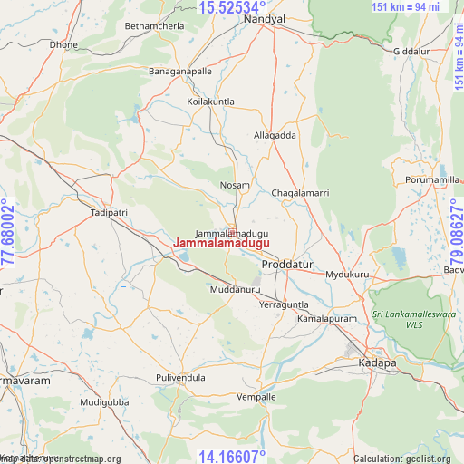
Jammalamadugu GPS coordinates[2]
14° 50' 48.372" North, 78° 22' 59.304" East
| Map corner | latitude | longitude |
|---|---|---|
| Upper-left | 15.52534°, | 77.68002° |
| Center: | 14.84677°, | 78.38314° |
| Lower-right: | 14.16607°, | 79.08627° |
| Map W x H: | 151.1×151.1 km | = 93.9×93.9mi |
| max Lat: | 34.9274° ⇑81.8% North |
| Jammalamadugu: | 14.84677° |
| min Lat: | ⇓18.2% South 8.09008° |
| min Long | Jammalamadugu | max Long |
| 68.82655° | 78.38314° | 96.81° |
| W 52.9%⇐ | ⇒47.1% E |
Elevation
Elevation of Jammalamadugu is 188 m = 617 ft, and this is 107.6 m = 353 ft below average elevation for this country.
| Max E: |
3681 m = 12077 ft | 52.4% |
| Avg. | 295.6 m = 970 ft | |
| Jammalamadugu | 188 m = 617 ft | |
Min E: |
1 m = 3 ft | 47.6% |
See also: Jammalamadugu elevation on elevation.city.
Geographical zone
Jammalamadugu is located in North Torrid zone (between Equator and Tropic of Cancer). Distance of this Northern Tropic circle is 955.1 km =593.5 mi to North.| Distance of | km | miles | from Jammalamadugu |
|---|---|---|---|
| North Pole | 8356.3 | 5192.4 | to North |
| Arctic Circle | 5750.4 | 3573.1 | to North |
| Tropic Cancer | 955.1 | 593.5 | to North |
| Equator | 1650.8 | 1025.8 | to South |


Nearby cities:
15 places around Jammalamadugu: (largest is in red/bold)
• Badvel
73.9 km =45.9 mi,  98°
98°
• Banganapalle
55 km =34.2 mi,  342°
342°
• Betamcherla
71.8 km =44.6 mi, 339°
• Chinnachowk
63.8 km =39.6 mi,  130°
130°
• Cuddapah
62.5 km =38.8 mi, 130°
• Dhone
82.1 km =51 mi,  317°
317°
• Diguvametta
77.5 km =48.2 mi,  38°
38°
• Erraguntla
28.6 km =17.8 mi,  143°
143°
• Giddalūr
82.7 km =51.4 mi, 44°
• Kāmalāpuram
41.4 km =25.7 mi, 131°
• Nandyāl
71 km =44.1 mi,  8°
8°
• Proddatūr
20.7 km =12.9 mi,  121°
121°
• Pulivendla
50.3 km =31.3 mi,  199°
199°
• Rāmāpuram
74 km =46 mi,  311°
311°
• Tādpatri
40.6 km =25.2 mi,  279°
279°
Sources, notices
• [Note1] Compared only with cities in India existing in our database
• [Src1] Map data: © OpenStreetMap contributors (CC-BY-SA)
• [Src2] Other city data from geonames.org with taken over terms of usage.
• [Src3] Geographical zone / Annual Mean Temperature by Robert A. Rohde @ Wikipedia
