Kāmalāpuram geodata
Kāmalāpuram (Andhra Pradesh) is a populated place; located in India in Asia/Kolkata (GMT+5.5) time zone. With population of 14,677 people, there are 2497 cities with bigger population in this country. Compared to other cities in India, 82.3% of cities are located further ↑North; 55.7% of cities are located further ←West and 61.3% of cities have higher elevation than Kāmalāpuram. Note1


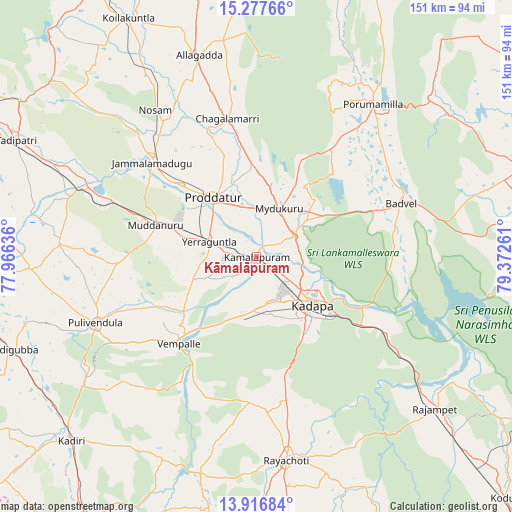
Kāmalāpuram GPS coordinates[2]
14° 35' 53.88" North, 78° 40' 10.128" East
| Map corner | latitude | longitude |
|---|---|---|
| Upper-left | 15.27766°, | 77.96636° |
| Center: | 14.5983°, | 78.66948° |
| Lower-right: | 13.91684°, | 79.37261° |
| Map W x H: | 151.3×151.3 km | = 94×94mi |
| max Lat: | 34.9274° ⇑82.3% North |
| Kāmalāpuram: | 14.5983° |
| min Lat: | ⇓17.7% South 8.09008° |
| min Long | Kāmalāpuram | max Long |
| 68.82655° | 78.66948° | 96.81° |
| W 55.7%⇐ | ⇒44.3% E |
Elevation
Elevation of Kāmalāpuram is 141 m = 463 ft, and this is 154.6 m = 507 ft below average elevation for this country.
| Max E: |
3681 m = 12077 ft | 61.3% |
| Avg. | 295.6 m = 970 ft | |
| Kāmalāpuram | 141 m = 463 ft | |
Min E: |
1 m = 3 ft | 38.7% |
See also: India elevation on elevation.city.
Geographical zone
Kāmalāpuram is located in North Torrid zone (between Equator and Tropic of Cancer). Distance of this Northern Tropic circle is 982.7 km =610.6 mi to North.| Distance of | km | miles | from Kāmalāpuram |
|---|---|---|---|
| North Pole | 8383.9 | 5209.5 | to North |
| Arctic Circle | 5778 | 3590.3 | to North |
| Tropic Cancer | 982.7 | 610.6 | to North |
| Equator | 1623.2 | 1008.6 | to South |


Nearby cities:
15 places around Kāmalāpuram: (largest is in red/bold)
• Badvel
45.4 km =28.2 mi,  68°
68°
• Banganapalle
93.1 km =57.8 mi,  329°
329°
• Chinnachowk
22.5 km =14 mi,  127°
127°
• Cuddapah
21.2 km =13.2 mi, 128°
• Diguvametta
90.2 km =56 mi,  10°
10°
• Erraguntla
14.7 km =9.1 mi,  287°
287°
• Giddalūr
90.6 km =56.3 mi,  17°
17°
• Jammalamadugu
41.4 km =25.7 mi,  311°
311°
• Kadiri
77.1 km =47.9 mi,  225°
225°
• Nāgireddipalli
59.1 km =36.7 mi, 128°
• Proddatūr
21.3 km =13.2 mi,  322°
322°
• Pulivendla
51.7 km =32.1 mi,  247°
247°
• Rāyachoti
60.8 km =37.8 mi,  171°
171°
• Rāzampeta
69.2 km =43 mi, 130°
• Tādpatri
78.8 km =49 mi,  295°
295°
Sources, notices
• [Note1] Compared only with cities in India existing in our database
• [Src1] Map data: © OpenStreetMap contributors (CC-BY-SA)
• [Src2] Other city data from geonames.org with taken over terms of usage.
• [Src3] Geographical zone / Annual Mean Temperature by Robert A. Rohde @ Wikipedia
