Rāyachoti geodata
Rāyachoti (Andhra Pradesh) is a populated place; located in India in Asia/Kolkata (GMT+5.5) time zone. With population of 81,433 people, there are 537 cities with bigger population in this country. Compared to other cities in India, 83.2% of cities are located further ↑North; 56.4% of cities are located further ←West and 73% of cities have lower elevation than Rāyachoti. Note1


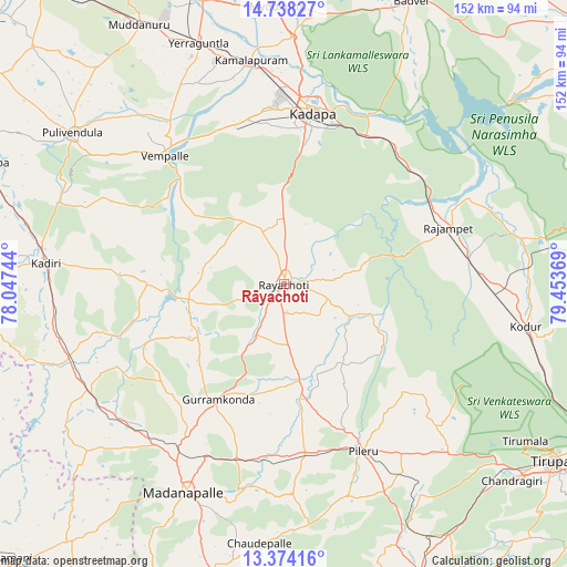
Rāyachoti GPS coordinates[2]
14° 3' 26.028" North, 78° 45' 2.016" East
| Map corner | latitude | longitude |
|---|---|---|
| Upper-left | 14.73827°, | 78.04744° |
| Center: | 14.05723°, | 78.75056° |
| Lower-right: | 13.37416°, | 79.45369° |
| Map W x H: | 151.7×151.7 km | = 94.3×94.3mi |
| max Lat: | 34.9274° ⇑83.2% North |
| Rāyachoti: | 14.05723° |
| min Lat: | ⇓16.8% South 8.09008° |
| min Long | Rāyachoti | max Long |
| 68.82655° | 78.75056° | 96.81° |
| W 56.4%⇐ | ⇒43.6% E |
Elevation
Elevation of Rāyachoti is 361 m = 1184 ft, and this is 65.4 m = 215 ft above average elevation for this country.
| Max E: |
3681 m = 12077 ft | 27% |
| Rāyachoti | 361 m 1184 ft | |
| Avg. | 295.6 m = 970 ft | |
Min E: |
1 m = 3 ft | 73% |
See also: Rāyachoti elevation on elevation.city.
Geographical zone
Rāyachoti is located in North Torrid zone (between Equator and Tropic of Cancer). Distance of this Northern Tropic circle is 1042.9 km =648 mi to North.| Distance of | km | miles | from Rāyachoti |
|---|---|---|---|
| North Pole | 8444 | 5246.9 | to North |
| Arctic Circle | 5838.2 | 3627.7 | to North |
| Tropic Cancer | 1042.9 | 648 | to North |
| Equator | 1563 | 971.2 | to South |


Nearby cities:
15 places around Rāyachoti: (largest is in red/bold)
• Badvel
83.6 km =51.9 mi,  23°
23°
• Chinnachowk
47.4 km =29.5 mi,  11°
11°
• Cuddapah
47.7 km =29.6 mi, 9°
• Erraguntla
68.5 km =42.6 mi,  340°
340°
• Kadiri
64 km =39.8 mi,  275°
275°
• Kāmalāpuram
60.8 km =37.8 mi,  351°
351°
• Madanapalle
62.4 km =38.8 mi,  205°
205°
• Narasingāpuram
79 km =49.1 mi,  129°
129°
• Nāgireddipalli
44.6 km =27.7 mi,  57°
57°
• Proddatūr
80.1 km =49.8 mi, 344°
• Pulivendla
69.6 km =43.2 mi,  305°
305°
• Punganūru
79.2 km =49.2 mi,  194°
194°
• Pākāla
78.2 km =48.6 mi,  149°
149°
• Rāzampeta
46.6 km =29 mi,  70°
70°
• Tirumala
76.9 km =47.8 mi,  122°
122°
Sources, notices
• [Note1] Compared only with cities in India existing in our database
• [Src1] Map data: © OpenStreetMap contributors (CC-BY-SA)
• [Src2] Other city data from geonames.org with taken over terms of usage.
• [Src3] Geographical zone / Annual Mean Temperature by Robert A. Rohde @ Wikipedia
