Erraguntla geodata
Erraguntla (Andhra Pradesh) is a populated place; located in India in Asia/Kolkata (GMT+5.5) time zone. With population of 27,874 people, there are 1546 cities with bigger population in this country. Compared to other cities in India, 82.2% of cities are located further ↑North; 54.6% of cities are located further ←West and 56.2% of cities have higher elevation than Erraguntla. Note1


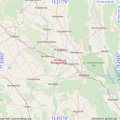
Erraguntla GPS coordinates[2]
14° 38' 18.708" North, 78° 32' 23.064" East
| Map corner | latitude | longitude |
|---|---|---|
| Upper-left | 15.31776°, | 77.83662° |
| Center: | 14.63853°, | 78.53974° |
| Lower-right: | 13.95719°, | 79.24287° |
| Map W x H: | 151.3×151.3 km | = 94×94mi |
| max Lat: | 34.9274° ⇑82.2% North |
| Erraguntla: | 14.63853° |
| min Lat: | ⇓17.8% South 8.09008° |
| min Long | Erraguntla | max Long |
| 68.82655° | 78.53974° | 96.81° |
| W 54.6%⇐ | ⇒45.4% E |
Elevation
Elevation of Erraguntla is 169 m = 554 ft, and this is 126.6 m = 415 ft below average elevation for this country.
| Max E: |
3681 m = 12077 ft | 56.2% |
| Avg. | 295.6 m = 970 ft | |
| Erraguntla | 169 m = 554 ft | |
Min E: |
1 m = 3 ft | 43.8% |
See also: India elevation on elevation.city.
Geographical zone
Erraguntla is located in North Torrid zone (between Equator and Tropic of Cancer). Distance of this Northern Tropic circle is 978.3 km =607.9 mi to North.| Distance of | km | miles | from Erraguntla |
|---|---|---|---|
| North Pole | 8379.4 | 5206.7 | to North |
| Arctic Circle | 5773.5 | 3587.5 | to North |
| Tropic Cancer | 978.3 | 607.9 | to North |
| Equator | 1627.7 | 1011.4 | to South |


Nearby cities:
15 places around Erraguntla: (largest is in red/bold)
• Badvel
57.5 km =35.7 mi,  78°
78°
• Banganapalle
82.7 km =51.4 mi,  335°
335°
• Chinnachowk
36.6 km =22.7 mi,  119°
119°
• Cuddapah
35.3 km =21.9 mi, 120°
• Dharmavaram
91.6 km =56.9 mi,  254°
254°
• Diguvametta
89.7 km =55.7 mi,  20°
20°
• Jammalamadugu
28.6 km =17.8 mi,  323°
323°
• Kadiri
71.5 km =44.4 mi,  214°
214°
• Kāmalāpuram
14.7 km =9.1 mi,  107°
107°
• Nāgireddipalli
73 km =45.4 mi, 124°
• Proddatūr
12.4 km =7.7 mi,  4°
4°
• Pulivendla
41.6 km =25.8 mi,  234°
234°
• Rāyachoti
68.5 km =42.6 mi,  160°
160°
• Rāzampeta
82.9 km =51.5 mi,  126°
126°
• Tādpatri
64.3 km =40 mi,  297°
297°
Sources, notices
• [Note1] Compared only with cities in India existing in our database
• [Src1] Map data: © OpenStreetMap contributors (CC-BY-SA)
• [Src2] Other city data from geonames.org with taken over terms of usage.
• [Src3] Geographical zone / Annual Mean Temperature by Robert A. Rohde @ Wikipedia
