Proddatūr geodata
Proddatūr (Andhra Pradesh) is a populated place; located in India in Asia/Kolkata (GMT+5.5) time zone. With population of 177,797 people, there are 239 cities with bigger population in this country. Compared to other cities in India, 82% of cities are located further ↑North; 54.6% of cities are located further ←West and 57.6% of cities have higher elevation than Proddatūr. Note1


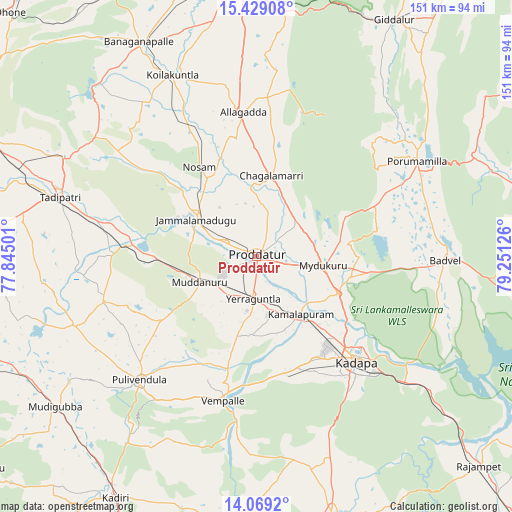
Proddatūr GPS coordinates[2]
14° 45' 0.72" North, 78° 32' 53.268" East
| Map corner | latitude | longitude |
|---|---|---|
| Upper-left | 15.42908°, | 77.84501° |
| Center: | 14.7502°, | 78.54813° |
| Lower-right: | 14.0692°, | 79.25126° |
| Map W x H: | 151.2×151.2 km | = 94×94mi |
| max Lat: | 34.9274° ⇑82% North |
| Proddatūr: | 14.7502° |
| min Lat: | ⇓18% South 8.09008° |
| min Long | Proddatūr | max Long |
| 68.82655° | 78.54813° | 96.81° |
| W 54.6%⇐ | ⇒45.4% E |
Elevation
Elevation of Proddatūr is 160 m = 525 ft, and this is 135.6 m = 445 ft below average elevation for this country.
| Max E: |
3681 m = 12077 ft | 57.6% |
| Avg. | 295.6 m = 970 ft | |
| Proddatūr | 160 m = 525 ft | |
Min E: |
1 m = 3 ft | 42.4% |
See also: Proddatūr elevation on elevation.city.
Geographical zone
Proddatūr is located in North Torrid zone (between Equator and Tropic of Cancer). Distance of this Northern Tropic circle is 965.9 km =600.2 mi to North.| Distance of | km | miles | from Proddatūr |
|---|---|---|---|
| North Pole | 8367 | 5199 | to North |
| Arctic Circle | 5761.1 | 3579.8 | to North |
| Tropic Cancer | 965.9 | 600.2 | to North |
| Equator | 1640.1 | 1019.1 | to South |


Nearby cities:
15 places around Proddatūr: (largest is in red/bold)
• Badvel
55.4 km =34.4 mi,  90°
90°
• Banganapalle
71.9 km =44.7 mi,  331°
331°
• Chinnachowk
43.5 km =27 mi,  134°
134°
• Cuddapah
42.2 km =26.2 mi,  135°
135°
• Diguvametta
77.8 km =48.3 mi,  22°
22°
• Erraguntla
12.4 km =7.7 mi,  184°
184°
• Giddalūr
80.4 km =50 mi,  30°
30°
• Jammalamadugu
20.7 km =12.9 mi,  301°
301°
• Kadiri
82.4 km =51.2 mi,  210°
210°
• Kāmalāpuram
21.3 km =13.2 mi, 142°
• Nandyāl
81.2 km =50.5 mi,  355°
355°
• Nāgireddipalli
80 km =49.7 mi, 131°
• Pulivendla
50.5 km =31.4 mi,  223°
223°
• Rāyachoti
80.1 km =49.8 mi,  164°
164°
• Tādpatri
60.4 km =37.5 mi,  286°
286°
Sources, notices
• [Note1] Compared only with cities in India existing in our database
• [Src1] Map data: © OpenStreetMap contributors (CC-BY-SA)
• [Src2] Other city data from geonames.org with taken over terms of usage.
• [Src3] Geographical zone / Annual Mean Temperature by Robert A. Rohde @ Wikipedia
