Nāgar Karnūl geodata
Nāgar Karnūl (Telangana) is a seat of a second-order administrative division; located in India in Asia/Kolkata (GMT+5.5) time zone. With population of 29,439 people, there are 1474 cities with bigger population in this country. Compared to other cities in India, 76.6% of cities are located further ↑North; 52.5% of cities are located further ←West and 79.7% of cities have lower elevation than Nāgar Karnūl. Note1


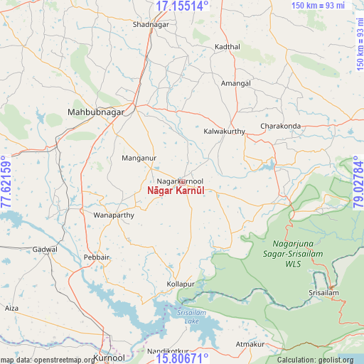
Nāgar Karnūl GPS coordinates[2]
16° 28' 55.56" North, 78° 19' 28.956" East
| Map corner | latitude | longitude |
|---|---|---|
| Upper-left | 17.15514°, | 77.62159° |
| Center: | 16.4821°, | 78.32471° |
| Lower-right: | 15.80671°, | 79.02784° |
| Map W x H: | 149.9×149.9 km | = 93.1×93.1mi |
| max Lat: | 34.9274° ⇑76.6% North |
| Nāgar Karnūl: | 16.4821° |
| min Lat: | ⇓23.4% South 8.09008° |
| min Long | Nāgar Karnūl | max Long |
| 68.82655° | 78.32471° | 96.81° |
| W 52.5%⇐ | ⇒47.5% E |
Elevation
Elevation of Nāgar Karnūl is 454 m = 1490 ft, and this is 158.4 m = 520 ft above average elevation for this country.
| Max E: |
3681 m = 12077 ft | 20.3% |
| Nāgar Karnūl | 454 m 1490 ft | |
| Avg. | 295.6 m = 970 ft | |
Min E: |
1 m = 3 ft | 79.7% |
See also: India elevation on elevation.city.
Geographical zone
Nāgar Karnūl is located in North Torrid zone (between Equator and Tropic of Cancer). Distance of this Northern Tropic circle is 773.3 km =480.5 mi to North.| Distance of | km | miles | from Nāgar Karnūl |
|---|---|---|---|
| North Pole | 8174.4 | 5079.3 | to North |
| Arctic Circle | 5568.5 | 3460.1 | to North |
| Tropic Cancer | 773.3 | 480.5 | to North |
| Equator | 1832.6 | 1138.7 | to South |


Nearby cities:
15 places around Nāgar Karnūl: (largest is in red/bold)
• Atmakūr
72.5 km =45 mi,  157°
157°
• Bālāpur
93.9 km =58.3 mi,  11°
11°
• Devarkonda
67.7 km =42.1 mi,  69°
69°
• Farrukhnagar
67.5 km =41.9 mi,  348°
348°
• Gadwāl
62.8 km =39 mi,  244°
244°
• Gopālur
57 km =35.4 mi,  284°
284°
• Kurnool
78.9 km =49 mi,  203°
203°
• Lal Bahadur Nagar
99.4 km =61.8 mi, 14°
• Mahbūbnagar
46.4 km =28.8 mi,  308°
308°
• Nandikotkūr
69.8 km =43.4 mi,  185°
185°
• Nārāyanpet
93.2 km =57.9 mi,  288°
288°
• Srīrāmnagar
87.5 km =54.4 mi,  355°
355°
• Srīsailain
73.8 km =45.9 mi,  128°
128°
• Wanparti
30.1 km =18.7 mi, 244°
• Ālampur
70 km =43.5 mi, 196°
Sources, notices
• [Note1] Compared only with cities in India existing in our database
• [Src1] Map data: © OpenStreetMap contributors (CC-BY-SA)
• [Src2] Other city data from geonames.org with taken over terms of usage.
• [Src3] Geographical zone / Annual Mean Temperature by Robert A. Rohde @ Wikipedia
