Kurnool geodata
Kurnool (Andhra Pradesh) is a populated place; located in India in Asia/Kolkata (GMT+5.5) time zone. With population of 460,184 people, there are 96 cities with bigger population in this country. Compared to other cities in India, 78.5% of cities are located further ↑North; 51% of cities are located further →East and 65% of cities have lower elevation than Kurnool. Note1


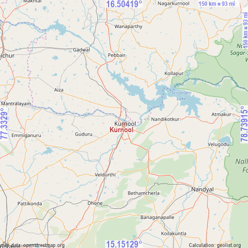
Kurnool GPS coordinates[2]
15° 49' 43.932" North, 78° 2' 9.672" East
| Map corner | latitude | longitude |
|---|---|---|
| Upper-left | 16.50419°, | 77.3329° |
| Center: | 15.82887°, | 78.03602° |
| Lower-right: | 15.15129°, | 78.73915° |
| Map W x H: | 150.4×150.4 km | = 93.5×93.5mi |
| max Lat: | 34.9274° ⇑78.5% North |
| Kurnool: | 15.82887° |
| min Lat: | ⇓21.5% South 8.09008° |
| min Long | Kurnool | max Long |
| 68.82655° | 78.03602° | 96.81° |
| W 49%⇐ | ⇒51% E |
Elevation
Elevation of Kurnool is 286 m = 938 ft, and this is 9.6 m = 31 ft below average elevation for this country.
| Max E: |
3681 m = 12077 ft | 35% |
| Avg. | 295.6 m = 970 ft | |
| Kurnool | 286 m = 938 ft | |
Min E: |
1 m = 3 ft | 65% |
See also: Kurnool elevation on elevation.city.
Geographical zone
Kurnool is located in North Torrid zone (between Equator and Tropic of Cancer). Distance of this Northern Tropic circle is 845.9 km =525.6 mi to North.| Distance of | km | miles | from Kurnool |
|---|---|---|---|
| North Pole | 8247.1 | 5124.5 | to North |
| Arctic Circle | 5641.2 | 3505.3 | to North |
| Tropic Cancer | 845.9 | 525.6 | to North |
| Equator | 1760 | 1093.6 | to South |


Nearby cities:
15 places around Kurnool: (largest is in red/bold)
• Atmakūr
59.2 km =36.8 mi,  84°
84°
• Banganapalle
60.4 km =37.5 mi,  160°
160°
• Betamcherla
43.6 km =27.1 mi, 164°
• Dhone
51.3 km =31.9 mi,  200°
200°
• Emmiganūr
59.5 km =37 mi,  263°
263°
• Gadwāl
52 km =32.3 mi,  330°
330°
• Kosigi
84.7 km =52.6 mi,  271°
271°
• Nandikotkūr
24.8 km =15.4 mi, 82°
• Nandyāl
61.8 km =38.4 mi,  129°
129°
• Nāgar Karnūl
78.9 km =49 mi,  23°
23°
• Rāichūr
83.9 km =52.1 mi,  299°
299°
• Rāmāpuram
62.9 km =39.1 mi, 196°
• Wanparti
60 km =37.3 mi,  3°
3°
• Ādoni
84.5 km =52.5 mi,  254°
254°
• Ālampur
11.9 km =7.4 mi,  61°
61°
Sources, notices
• [Note1] Compared only with cities in India existing in our database
• [Src1] Map data: © OpenStreetMap contributors (CC-BY-SA)
• [Src2] Other city data from geonames.org with taken over terms of usage.
• [Src3] Geographical zone / Annual Mean Temperature by Robert A. Rohde @ Wikipedia
