Nandyāl geodata
Nandyāl (Andhra Pradesh) is a populated place; located in India in Asia/Kolkata (GMT+5.5) time zone. With population of 165,337 people, there are 259 cities with bigger population in this country. Compared to other cities in India, 79.8% of cities are located further ↑North; 54.1% of cities are located further ←West and 51.9% of cities have lower elevation than Nandyāl. Note1


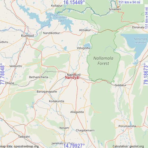
Nandyāl GPS coordinates[2]
15° 28' 40.764" North, 78° 29' 0.96" East
| Map corner | latitude | longitude |
|---|---|---|
| Upper-left | 16.15449°, | 77.78048° |
| Center: | 15.47799°, | 78.4836° |
| Lower-right: | 14.79927°, | 79.18673° |
| Map W x H: | 150.7×150.7 km | = 93.6×93.6mi |
| max Lat: | 34.9274° ⇑79.8% North |
| Nandyāl: | 15.47799° |
| min Lat: | ⇓20.2% South 8.09008° |
| min Long | Nandyāl | max Long |
| 68.82655° | 78.4836° | 96.81° |
| W 54.1%⇐ | ⇒45.9% E |
Elevation
Elevation of Nandyāl is 213 m = 699 ft, and this is 82.6 m = 271 ft below average elevation for this country.
| Max E: |
3681 m = 12077 ft | 48.1% |
| Avg. | 295.6 m = 970 ft | |
| Nandyāl | 213 m = 699 ft | |
Min E: |
1 m = 3 ft | 51.9% |
See also: Nandyāl elevation on elevation.city.
Geographical zone
Nandyāl is located in North Torrid zone (between Equator and Tropic of Cancer). Distance of this Northern Tropic circle is 884.9 km =549.9 mi to North.| Distance of | km | miles | from Nandyāl |
|---|---|---|---|
| North Pole | 8286.1 | 5148.7 | to North |
| Arctic Circle | 5680.2 | 3529.5 | to North |
| Tropic Cancer | 884.9 | 549.9 | to North |
| Equator | 1721 | 1069.4 | to South |


Nearby cities:
15 places around Nandyāl: (largest is in red/bold)
• Atmakūr
46.2 km =28.7 mi,  13°
13°
• Banganapalle
32.8 km =20.4 mi,  237°
237°
• Betamcherla
36.1 km =22.4 mi,  265°
265°
• Cumbum
68.2 km =42.4 mi,  80°
80°
• Dhone
66.2 km =41.1 mi,  262°
262°
• Diguvametta
38.2 km =23.7 mi,  103°
103°
• Giddalūr
48.8 km =30.3 mi, 103°
• Jammalamadugu
71 km =44.1 mi,  188°
188°
• Kurnool
61.8 km =38.4 mi,  309°
309°
• Nandikotkūr
48.1 km =29.9 mi,  331°
331°
• Proddatūr
81.2 km =50.5 mi,  175°
175°
• Rāmāpuram
69.4 km =43.1 mi,  252°
252°
• Srīsailain
77.8 km =48.3 mi,  31°
31°
• Tādpatri
81.2 km =50.5 mi,  218°
218°
• Ālampur
58.3 km =36.2 mi,  320°
320°
Sources, notices
• [Note1] Compared only with cities in India existing in our database
• [Src1] Map data: © OpenStreetMap contributors (CC-BY-SA)
• [Src2] Other city data from geonames.org with taken over terms of usage.
• [Src3] Geographical zone / Annual Mean Temperature by Robert A. Rohde @ Wikipedia
