Betamcherla geodata
Betamcherla (Andhra Pradesh) is a populated place; located in India in Asia/Kolkata (GMT+5.5) time zone. With population of 35,417 people, there are 1227 cities with bigger population in this country. Compared to other cities in India, 79.9% of cities are located further ↑North; 50.6% of cities are located further ←West and 77.5% of cities have lower elevation than Betamcherla. Note1


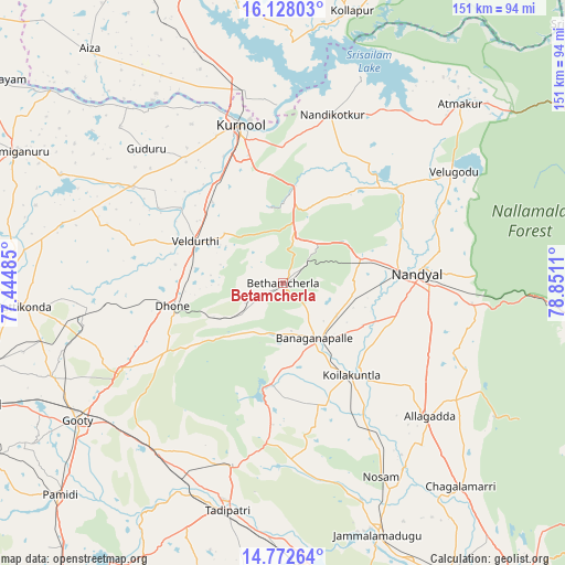
Betamcherla GPS coordinates[2]
15° 27' 5.184" North, 78° 8' 52.692" East
| Map corner | latitude | longitude |
|---|---|---|
| Upper-left | 16.12803°, | 77.44485° |
| Center: | 15.45144°, | 78.14797° |
| Lower-right: | 14.77264°, | 78.8511° |
| Map W x H: | 150.7×150.7 km | = 93.6×93.6mi |
| max Lat: | 34.9274° ⇑79.9% North |
| Betamcherla: | 15.45144° |
| min Lat: | ⇓20.1% South 8.09008° |
| min Long | Betamcherla | max Long |
| 68.82655° | 78.14797° | 96.81° |
| W 50.6%⇐ | ⇒49.4% E |
Elevation
Elevation of Betamcherla is 424 m = 1391 ft, and this is 128.4 m = 421 ft above average elevation for this country.
| Max E: |
3681 m = 12077 ft | 22.5% |
| Betamcherla | 424 m 1391 ft | |
| Avg. | 295.6 m = 970 ft | |
Min E: |
1 m = 3 ft | 77.5% |
See also: India elevation on elevation.city.
Geographical zone
Betamcherla is located in North Torrid zone (between Equator and Tropic of Cancer). Distance of this Northern Tropic circle is 887.9 km =551.7 mi to North.| Distance of | km | miles | from Betamcherla |
|---|---|---|---|
| North Pole | 8289 | 5150.5 | to North |
| Arctic Circle | 5683.1 | 3531.3 | to North |
| Tropic Cancer | 887.9 | 551.7 | to North |
| Equator | 1718 | 1067.5 | to South |


Nearby cities:
15 places around Betamcherla: (largest is in red/bold)
• Atmakūr
67 km =41.6 mi,  44°
44°
• Banganapalle
17.1 km =10.6 mi,  150°
150°
• Dhone
30.3 km =18.8 mi,  258°
258°
• Diguvametta
73.3 km =45.5 mi,  94°
94°
• Emmiganūr
79.6 km =49.5 mi,  296°
296°
• Giddalūr
83.8 km =52.1 mi,  95°
95°
• Guntakal Junction
89.8 km =55.8 mi,  249°
249°
• Jammalamadugu
71.8 km =44.6 mi,  159°
159°
• Kurnool
43.6 km =27.1 mi,  344°
344°
• Nandikotkūr
46.8 km =29.1 mi,  15°
15°
• Nandyāl
36.1 km =22.4 mi, 85°
• Proddatūr
89 km =55.3 mi, 151°
• Rāmāpuram
35.2 km =21.9 mi,  238°
238°
• Tādpatri
62.2 km =38.6 mi,  193°
193°
• Ālampur
47.7 km =29.6 mi,  358°
358°
Sources, notices
• [Note1] Compared only with cities in India existing in our database
• [Src1] Map data: © OpenStreetMap contributors (CC-BY-SA)
• [Src2] Other city data from geonames.org with taken over terms of usage.
• [Src3] Geographical zone / Annual Mean Temperature by Robert A. Rohde @ Wikipedia
