Baswa geodata
Baswa (Rajasthan) is a populated place; located in India in Asia/Kolkata (GMT+5.5) time zone. With population of 22,515 people, there are 1876 cities with bigger population in this country. Compared to other cities in India, 79.7% of cities are located further ↓South; 67.4% of cities are located further →East and 66.6% of cities have lower elevation than Baswa. Note1


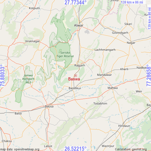
Baswa GPS coordinates[2]
27° 8' 58.38" North, 76° 35' 0.42" East
| Map corner | latitude | longitude |
|---|---|---|
| Upper-left | 27.77344°, | 75.88033° |
| Center: | 27.14955°, | 76.58345° |
| Lower-right: | 26.52215°, | 77.28658° |
| Map W x H: | 139.1×139.1 km | = 86.4×86.4mi |
| max Lat: | 34.9274° ⇑20.3% North |
| Baswa: | 27.14955° |
| min Lat: | ⇓79.7% South 8.09008° |
| min Long | Baswa | max Long |
| 68.82655° | 76.58345° | 96.81° |
| W 32.6%⇐ | ⇒67.4% E |
Elevation
Elevation of Baswa is 299 m = 981 ft, and this is 3.4 m = 11 ft above average elevation for this country.
| Max E: |
3681 m = 12077 ft | 33.4% |
| Baswa | 299 m 981 ft | |
| Avg. | 295.6 m = 970 ft | |
Min E: |
1 m = 3 ft | 66.6% |
See also: India elevation on elevation.city.
Geographical zone
Baswa is located in North temperate zone (between Tropic of Cancer and the Arctic Circle). Distance of this Northern Tropic circle is 412.8 km =256.5 mi to South.| Distance of | km | miles | from Baswa |
|---|---|---|---|
| North Pole | 6988.3 | 4342.3 | to North |
| Arctic Circle | 4382.4 | 2723.1 | to North |
| Tropic Cancer | 412.8 | 256.5 | to South |
| Equator | 3018.7 | 1875.7 | to South |


Nearby cities:
15 places around Baswa: (largest is in red/bold)
• Abhaneri
16 km =9.9 mi,  171°
171°
• Alwar
46.1 km =28.6 mi,  5°
5°
• Basi
63.7 km =39.6 mi,  236°
236°
• Bhasāwar
47.6 km =29.6 mi,  104°
104°
• Bāndīkūi
11 km =6.8 mi,  185°
185°
• Dausa
37.9 km =23.5 mi,  220°
220°
• Govindgarh
56.9 km =35.4 mi,  46°
46°
• Hindaun
64.3 km =40 mi,  135°
135°
• Mahwah
36.3 km =22.6 mi,  108°
108°
• Manoharpur
64.8 km =40.3 mi,  284°
284°
• Nagar
59.4 km =36.9 mi,  59°
59°
• Nādbai
61.1 km =38 mi,  82°
82°
• Rājgarh
10.5 km =6.5 mi,  21°
21°
• Todabhim
34.7 km =21.6 mi, 138°
• Wer
60.5 km =37.6 mi, 103°
Sources, notices
• [Note1] Compared only with cities in India existing in our database
• [Src1] Map data: © OpenStreetMap contributors (CC-BY-SA)
• [Src2] Other city data from geonames.org with taken over terms of usage.
• [Src3] Geographical zone / Annual Mean Temperature by Robert A. Rohde @ Wikipedia
