Behror geodata
Behror (Rajasthan) is a populated place; located in India in Asia/Kolkata (GMT+5.5) time zone. With population of 25,815 people, there are 1648 cities with bigger population in this country. Compared to other cities in India, 83.9% of cities are located further ↓South; 70.9% of cities are located further →East and 69.7% of cities have lower elevation than Behror. Note1


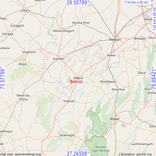
Behror GPS coordinates[2]
27° 53' 17.952" North, 76° 16' 51.888" East
| Map corner | latitude | longitude |
|---|---|---|
| Upper-left | 28.50799°, | 75.57796° |
| Center: | 27.88832°, | 76.28108° |
| Lower-right: | 27.26508°, | 76.98421° |
| Map W x H: | 138.2×138.2 km | = 85.9×85.9mi |
| max Lat: | 34.9274° ⇑16.1% North |
| Behror: | 27.88832° |
| min Lat: | ⇓83.9% South 8.09008° |
| min Long | Behror | max Long |
| 68.82655° | 76.28108° | 96.81° |
| W 29.1%⇐ | ⇒70.9% E |
Elevation
Elevation of Behror is 325 m = 1066 ft, and this is 29.4 m = 96 ft above average elevation for this country.
| Max E: |
3681 m = 12077 ft | 30.3% |
| Behror | 325 m 1066 ft | |
| Avg. | 295.6 m = 970 ft | |
Min E: |
1 m = 3 ft | 69.7% |
See also: India elevation on elevation.city.
Geographical zone
Behror is located in North temperate zone (between Tropic of Cancer and the Arctic Circle). Distance of this Northern Tropic circle is 495 km =307.6 mi to South.| Distance of | km | miles | from Behror |
|---|---|---|---|
| North Pole | 6906.2 | 4291.3 | to North |
| Arctic Circle | 4300.3 | 2672.1 | to North |
| Tropic Cancer | 495 | 307.6 | to South |
| Equator | 3100.9 | 1926.8 | to South |


Nearby cities:
15 places around Behror: (largest is in red/bold)
• Alwar
49.6 km =30.8 mi,  136°
136°
• Ateli Mandi
23.7 km =14.7 mi,  354°
354°
• Bāwal
36 km =22.4 mi,  55°
55°
• Dhāruhera
61.7 km =38.3 mi, 55°
• Kanīna Khās
49.3 km =30.6 mi,  3°
3°
• Khetri
50.2 km =31.2 mi,  284°
284°
• Kishangarh
44.8 km =27.8 mi,  99°
99°
• Kotputli
22.2 km =13.8 mi,  201°
201°
• Mahendragarh
44.2 km =27.5 mi,  343°
343°
• Mandāwar
26.6 km =16.5 mi, 95°
• Neem ka Thana
51.4 km =31.9 mi,  251°
251°
• Nārnaul
24.3 km =15.1 mi,  315°
315°
• Rewāri
47.8 km =29.7 mi,  43°
43°
• Shāhpura
63.7 km =39.6 mi,  209°
209°
• Tijāra
56.7 km =35.2 mi,  84°
84°
Sources, notices
• [Note1] Compared only with cities in India existing in our database
• [Src1] Map data: © OpenStreetMap contributors (CC-BY-SA)
• [Src2] Other city data from geonames.org with taken over terms of usage.
• [Src3] Geographical zone / Annual Mean Temperature by Robert A. Rohde @ Wikipedia
