Rājgarh geodata
Rājgarh (Rajasthan) is a populated place; located in India in Asia/Kolkata (GMT+5.5) time zone. With population of 26,953 people, there are 1586 cities with bigger population in this country. Compared to other cities in India, 80.4% of cities are located further ↓South; 67% of cities are located further →East and 68.8% of cities have lower elevation than Rājgarh. Note1


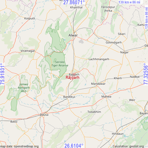
Rājgarh GPS coordinates[2]
27° 14' 14.316" North, 76° 37' 20.748" East
| Map corner | latitude | longitude |
|---|---|---|
| Upper-left | 27.86071°, | 75.91931° |
| Center: | 27.23731°, | 76.62243° |
| Lower-right: | 26.6104°, | 77.32556° |
| Map W x H: | 139×139 km | = 86.4×86.4mi |
| max Lat: | 34.9274° ⇑19.6% North |
| Rājgarh: | 27.23731° |
| min Lat: | ⇓80.4% South 8.09008° |
| min Long | Rājgarh | max Long |
| 68.82655° | 76.62243° | 96.81° |
| W 33%⇐ | ⇒67% E |
Elevation
Elevation of Rājgarh is 314 m = 1030 ft, and this is 18.4 m = 60 ft above average elevation for this country.
| Max E: |
3681 m = 12077 ft | 31.2% |
| Rājgarh | 314 m 1030 ft | |
| Avg. | 295.6 m = 970 ft | |
Min E: |
1 m = 3 ft | 68.8% |
See also: India elevation on elevation.city.
Geographical zone
Rājgarh is located in North temperate zone (between Tropic of Cancer and the Arctic Circle). Distance of this Northern Tropic circle is 422.6 km =262.6 mi to South.| Distance of | km | miles | from Rājgarh |
|---|---|---|---|
| North Pole | 6978.6 | 4336.3 | to North |
| Arctic Circle | 4372.7 | 2717.1 | to North |
| Tropic Cancer | 422.6 | 262.6 | to South |
| Equator | 3028.5 | 1881.8 | to South |


Nearby cities:
15 places around Rājgarh: (largest is in red/bold)
• Abhaneri
25.6 km =15.9 mi,  183°
183°
• Alwar
36.2 km =22.5 mi,  0°
0°
• Baswa
10.5 km =6.5 mi,  201°
201°
• Bhasāwar
47.6 km =29.6 mi,  117°
117°
• Bāndīkūi
21.3 km =13.2 mi,  193°
193°
• Dausa
47.9 km =29.8 mi,  216°
216°
• Govindgarh
47.6 km =29.6 mi,  51°
51°
• Kishangarh
65.5 km =40.7 mi,  9°
9°
• Kotputli
66.4 km =41.3 mi,  321°
321°
• Mahwah
37.3 km =23.2 mi, 124°
• Manoharpur
66.8 km =41.5 mi,  275°
275°
• Nagar
51.5 km =32 mi,  66°
66°
• Nādbai
56.7 km =35.2 mi,  91°
91°
• Todabhim
40.5 km =25.2 mi,  151°
151°
• Wer
60 km =37.3 mi,  113°
113°
Sources, notices
• [Note1] Compared only with cities in India existing in our database
• [Src1] Map data: © OpenStreetMap contributors (CC-BY-SA)
• [Src2] Other city data from geonames.org with taken over terms of usage.
• [Src3] Geographical zone / Annual Mean Temperature by Robert A. Rohde @ Wikipedia
