Bāndīkūi geodata
Bāndīkūi (Rajasthan) is a populated place; located in India in Asia/Kolkata (GMT+5.5) time zone. With population of 16,165 people, there are 2361 cities with bigger population in this country. Compared to other cities in India, 78.8% of cities are located further ↓South; 67.6% of cities are located further →East and 64.7% of cities have lower elevation than Bāndīkūi. Note1


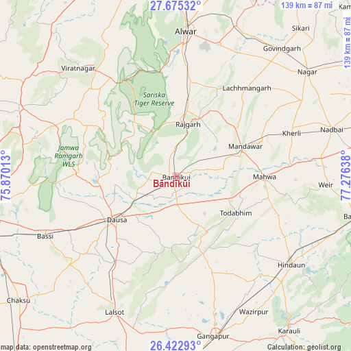
Bāndīkūi GPS coordinates[2]
27° 3' 3.132" North, 76° 34' 23.7" East
| Map corner | latitude | longitude |
|---|---|---|
| Upper-left | 27.67532°, | 75.87013° |
| Center: | 27.05087°, | 76.57325° |
| Lower-right: | 26.42293°, | 77.27638° |
| Map W x H: | 139.3×139.3 km | = 86.6×86.6mi |
| max Lat: | 34.9274° ⇑21.2% North |
| Bāndīkūi: | 27.05087° |
| min Lat: | ⇓78.8% South 8.09008° |
| min Long | Bāndīkūi | max Long |
| 68.82655° | 76.57325° | 96.81° |
| W 32.4%⇐ | ⇒67.6% E |
Elevation
Elevation of Bāndīkūi is 283 m = 928 ft, and this is 12.6 m = 41 ft below average elevation for this country.
| Max E: |
3681 m = 12077 ft | 35.3% |
| Avg. | 295.6 m = 970 ft | |
| Bāndīkūi | 283 m = 928 ft | |
Min E: |
1 m = 3 ft | 64.7% |
See also: India elevation on elevation.city.
Geographical zone
Bāndīkūi is located in North temperate zone (between Tropic of Cancer and the Arctic Circle). Distance of this Northern Tropic circle is 401.9 km =249.7 mi to South.| Distance of | km | miles | from Bāndīkūi |
|---|---|---|---|
| North Pole | 6999.3 | 4349.2 | to North |
| Arctic Circle | 4393.4 | 2729.9 | to North |
| Tropic Cancer | 401.9 | 249.7 | to South |
| Equator | 3007.8 | 1869 | to South |


Nearby cities:
15 places around Bāndīkūi: (largest is in red/bold)
• Abhaneri
5.9 km =3.7 mi,  144°
144°
• Alwar
57.1 km =35.5 mi,  5°
5°
• Basi
57.4 km =35.7 mi,  244°
244°
• Baswa
11 km =6.8 mi, 5°
• Bhasāwar
47.1 km =29.3 mi,  91°
91°
• Dausa
29.6 km =18.4 mi,  232°
232°
• Gangāpur
65.9 km =40.9 mi,  167°
167°
• Govindgarh
65.7 km =40.8 mi,  39°
39°
• Hindaun
57.8 km =35.9 mi,  127°
127°
• Lālsot
59.8 km =37.2 mi,  203°
203°
• Mahwah
35.5 km =22.1 mi, 90°
• Nādbai
64.5 km =40.1 mi,  72°
72°
• Rājgarh
21.3 km =13.2 mi, 13°
• Todabhim
28.4 km =17.6 mi,  121°
121°
• Wer
59.8 km =37.2 mi, 93°
Sources, notices
• [Note1] Compared only with cities in India existing in our database
• [Src1] Map data: © OpenStreetMap contributors (CC-BY-SA)
• [Src2] Other city data from geonames.org with taken over terms of usage.
• [Src3] Geographical zone / Annual Mean Temperature by Robert A. Rohde @ Wikipedia
