Jhīnjhak geodata
Jhīnjhak (Uttar Pradesh) is a populated place; located in India in Asia/Kolkata (GMT+5.5) time zone. With population of 23,499 people, there are 1800 cities with bigger population in this country. Compared to other cities in India, 75.1% of cities are located further ↓South; 66% of cities are located further ←West and 61.1% of cities have higher elevation than Jhīnjhak. Note1


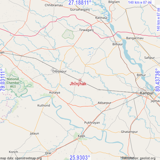
Jhīnjhak GPS coordinates[2]
26° 33' 39.348" North, 79° 44' 3.228" East
| Map corner | latitude | longitude |
|---|---|---|
| Upper-left | 27.18811°, | 79.03111° |
| Center: | 26.56093°, | 79.73423° |
| Lower-right: | 25.9303°, | 80.43736° |
| Map W x H: | 139.9×139.9 km | = 86.9×86.9mi |
| max Lat: | 34.9274° ⇑24.9% North |
| Jhīnjhak: | 26.56093° |
| min Lat: | ⇓75.1% South 8.09008° |
| min Long | Jhīnjhak | max Long |
| 68.82655° | 79.73423° | 96.81° |
| W 66%⇐ | ⇒34% E |
Elevation
Elevation of Jhīnjhak is 142 m = 466 ft, and this is 153.6 m = 504 ft below average elevation for this country.
| Max E: |
3681 m = 12077 ft | 61.1% |
| Avg. | 295.6 m = 970 ft | |
| Jhīnjhak | 142 m = 466 ft | |
Min E: |
1 m = 3 ft | 38.9% |
See also: India elevation on elevation.city.
Geographical zone
Jhīnjhak is located in North temperate zone (between Tropic of Cancer and the Arctic Circle). Distance of this Northern Tropic circle is 347.4 km =215.9 mi to South.| Distance of | km | miles | from Jhīnjhak |
|---|---|---|---|
| North Pole | 7053.8 | 4383 | to North |
| Arctic Circle | 4447.9 | 2763.8 | to North |
| Tropic Cancer | 347.4 | 215.9 | to South |
| Equator | 2953.3 | 1835.1 | to South |


Nearby cities:
15 places around Jhīnjhak: (largest is in red/bold)
• Akbarpur
29.1 km =18.1 mi,  132°
132°
• Auraiya
24.8 km =15.4 mi,  244°
244°
• Bakewar
56.6 km =35.2 mi,  281°
281°
• Bharthana
55.2 km =34.3 mi,  292°
292°
• Bidhūna
34.9 km =21.7 mi,  320°
320°
• Bilhaur
45.4 km =28.2 mi,  46°
46°
• Bithūr
53.6 km =33.3 mi,  84°
84°
• Indergarh
42.1 km =26.2 mi,  351°
351°
• Kālpi
49.4 km =30.7 mi,  180°
180°
• Phaphūnd
27.2 km =16.9 mi, 278°
• Pukhrāyān
38.9 km =24.2 mi,  164°
164°
• Rura
18.4 km =11.4 mi,  115°
115°
• Saurikh
57.6 km =35.8 mi,  334°
334°
• Sikandra
23.9 km =14.9 mi,  205°
205°
• Tālgrām
54.8 km =34.1 mi, 351°
Sources, notices
• [Note1] Compared only with cities in India existing in our database
• [Src1] Map data: © OpenStreetMap contributors (CC-BY-SA)
• [Src2] Other city data from geonames.org with taken over terms of usage.
• [Src3] Geographical zone / Annual Mean Temperature by Robert A. Rohde @ Wikipedia
