Auraiya geodata
Auraiya (Uttar Pradesh) is a populated place; located in India in Asia/Kolkata (GMT+5.5) time zone. With population of 70,508 people, there are 619 cities with bigger population in this country. Compared to other cities in India, 74.2% of cities are located further ↓South; 63.9% of cities are located further ←West and 60.8% of cities have higher elevation than Auraiya. Note1


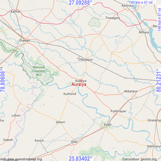
Auraiya GPS coordinates[2]
26° 27' 54.612" North, 79° 30' 33.048" East
| Map corner | latitude | longitude |
|---|---|---|
| Upper-left | 27.09288°, | 78.80606° |
| Center: | 26.46517°, | 79.50918° |
| Lower-right: | 25.83402°, | 80.21231° |
| Map W x H: | 140×140 km | = 87×87mi |
| max Lat: | 34.9274° ⇑25.8% North |
| Auraiya: | 26.46517° |
| min Lat: | ⇓74.2% South 8.09008° |
| min Long | Auraiya | max Long |
| 68.82655° | 79.50918° | 96.81° |
| W 63.9%⇐ | ⇒36.1% E |
Elevation
Elevation of Auraiya is 144 m = 472 ft, and this is 151.6 m = 497 ft below average elevation for this country.
| Max E: |
3681 m = 12077 ft | 60.8% |
| Avg. | 295.6 m = 970 ft | |
| Auraiya | 144 m = 472 ft | |
Min E: |
1 m = 3 ft | 39.2% |
See also: Auraiya elevation on elevation.city.
Geographical zone
Auraiya is located in North temperate zone (between Tropic of Cancer and the Arctic Circle). Distance of this Northern Tropic circle is 336.7 km =209.2 mi to South.| Distance of | km | miles | from Auraiya |
|---|---|---|---|
| North Pole | 7064.4 | 4389.6 | to North |
| Arctic Circle | 4458.5 | 2770.4 | to North |
| Tropic Cancer | 336.7 | 209.2 | to South |
| Equator | 2942.7 | 1828.5 | to South |


Nearby cities:
15 places around Auraiya: (largest is in red/bold)
• Akbarpur
44.7 km =27.8 mi,  101°
101°
• Bakewar
39.7 km =24.7 mi,  303°
303°
• Bharthana
42.8 km =26.6 mi,  318°
318°
• Bidhūna
37.4 km =23.2 mi,  359°
359°
• Jhīnjhak
24.8 km =15.4 mi,  64°
64°
• Jālaun
39.5 km =24.5 mi,  205°
205°
• Kālpi
44.7 km =27.8 mi,  150°
150°
• Lakhnā
41.3 km =25.7 mi, 299°
• Mādhogarh
38.5 km =23.9 mi,  236°
236°
• Phaphūnd
15.5 km =9.6 mi,  343°
343°
• Pukhrāyān
42.3 km =26.3 mi,  129°
129°
• Rura
39.1 km =24.3 mi,  85°
85°
• Rāmpura
35 km =21.7 mi,  248°
248°
• Sarai Ekdil
51.7 km =32.1 mi,  306°
306°
• Sikandra
16.2 km =10.1 mi, 132°
Sources, notices
• [Note1] Compared only with cities in India existing in our database
• [Src1] Map data: © OpenStreetMap contributors (CC-BY-SA)
• [Src2] Other city data from geonames.org with taken over terms of usage.
• [Src3] Geographical zone / Annual Mean Temperature by Robert A. Rohde @ Wikipedia
