Dīnānagar geodata
Dīnānagar (Punjab) is a populated place; located in India in Asia/Kolkata (GMT+5.5) time zone. With population of 23,339 people, there are 1815 cities with bigger population in this country. Compared to other cities in India, 98.1% of cities are located further ↓South; 78.7% of cities are located further →East and 63.2% of cities have lower elevation than Dīnānagar. Note1


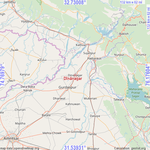
Dīnānagar GPS coordinates[2]
32° 8' 11.904" North, 75° 28' 22.476" East
| Map corner | latitude | longitude |
|---|---|---|
| Upper-left | 32.73008°, | 74.76979° |
| Center: | 32.13664°, | 75.47291° |
| Lower-right: | 31.53931°, | 76.17604° |
| Map W x H: | 132.4×132.4 km | = 82.3×82.3mi |
| max Lat: | 34.9274° ⇑1.9% North |
| Dīnānagar: | 32.13664° |
| min Lat: | ⇓98.1% South 8.09008° |
| min Long | Dīnānagar | max Long |
| 68.82655° | 75.47291° | 96.81° |
| W 21.3%⇐ | ⇒78.7% E |
Elevation
Elevation of Dīnānagar is 273 m = 896 ft, and this is 22.6 m = 74 ft below average elevation for this country.
| Max E: |
3681 m = 12077 ft | 36.8% |
| Avg. | 295.6 m = 970 ft | |
| Dīnānagar | 273 m = 896 ft | |
Min E: |
1 m = 3 ft | 63.2% |
See also: India elevation on elevation.city.
Geographical zone
Dīnānagar is located in North temperate zone (between Tropic of Cancer and the Arctic Circle). Distance of this Northern Tropic circle is 967.3 km =601.1 mi to South.| Distance of | km | miles | from Dīnānagar |
|---|---|---|---|
| North Pole | 6433.8 | 3997.8 | to North |
| Arctic Circle | 3827.9 | 2378.5 | to North |
| Tropic Cancer | 967.3 | 601.1 | to South |
| Equator | 3573.3 | 2220.3 | to South |


Nearby cities:
15 places around Dīnānagar: (largest is in red/bold)
• Batāla
44.4 km =27.6 mi,  214°
214°
• Dasūya
39.4 km =24.5 mi,  154°
154°
• Derā Nānak
43.4 km =27 mi,  255°
255°
• Dhāriwāl
24.5 km =15.2 mi, 214°
• Garhdiwāla
51.4 km =31.9 mi, 148°
• Hirānagar
40.1 km =24.9 mi,  331°
331°
• Hājipur
31.9 km =19.8 mi,  123°
123°
• Kalanaur
33.4 km =20.8 mi,  245°
245°
• Kathua
26.3 km =16.3 mi,  10°
10°
• Kotla
54.2 km =33.7 mi,  76°
76°
• Mukeriān
24.4 km =15.2 mi, 146°
• Parol
23.6 km =14.7 mi,  351°
351°
• Pathānkot
22.9 km =14.2 mi,  47°
47°
• Qādiān
36.1 km =22.4 mi,  194°
194°
• Talwāra
44.8 km =27.8 mi, 119°
Sources, notices
• [Note1] Compared only with cities in India existing in our database
• [Src1] Map data: © OpenStreetMap contributors (CC-BY-SA)
• [Src2] Other city data from geonames.org with taken over terms of usage.
• [Src3] Geographical zone / Annual Mean Temperature by Robert A. Rohde @ Wikipedia
