Zāwītah geodata
Zāwītah (Dahūk) is a seat of a third-order administrative division; located in Iraq in Asia/Baghdad (GMT+3) time zone. In our database, there are 71 cities with bigger population. Compared to other cities in Iraq, 94.4% of cities are located further ↓South; 83.8% of cities are located further →East and 89.4% of cities have lower elevation than Zāwītah. Note1


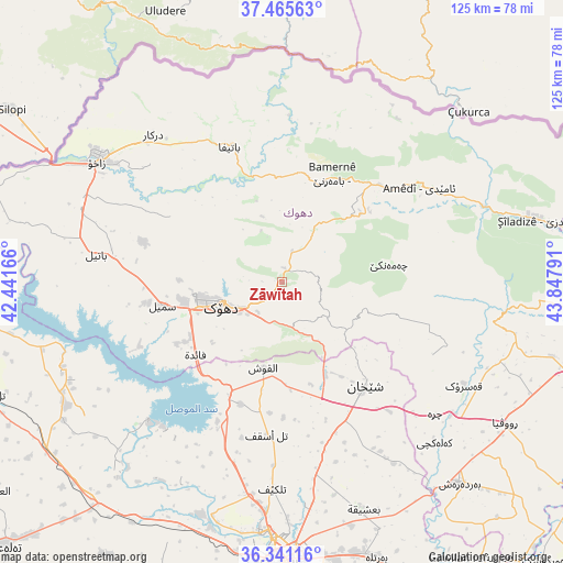
Zāwītah GPS coordinates[2]
36° 54' 19.692" North, 43° 8' 41.208" East
| Map corner | latitude | longitude |
|---|---|---|
| Upper-left | 37.46563°, | 42.44166° |
| Center: | 36.90547°, | 43.14478° |
| Lower-right: | 36.34116°, | 43.84791° |
| Map W x H: | 125×125 km | = 77.7×77.7mi |
| max Lat: | 37.22781° ⇑5.6% North |
| Zāwītah: | 36.90547° |
| min Lat: | ⇓94.4% South 29.97421° |
| min Long | Zāwītah | max Long |
| 40.28586° | 43.14478° | 48.47309° |
| W 16.2%⇐ | ⇒83.8% E |
Elevation
Elevation of Zāwītah is 848 m = 2782 ft, and this is 555 m = 1821 ft above average elevation for this country.
| Max E: |
1316 m = 4318 ft | 10.6% |
| Zāwītah | 848 m 2782 ft | |
| Avg. | 293 m = 961 ft | |
Min E: |
1 m = 3 ft | 89.4% |
See also: Iraq elevation on elevation.city.
Geographical zone
Zāwītah is located in North temperate zone (between Tropic of Cancer and the Arctic Circle). Distance of this Northern Tropic circle is 1497.6 km =930.6 mi to South.| Distance of | km | miles | from Zāwītah |
|---|---|---|---|
| North Pole | 5903.6 | 3668.3 | to North |
| Arctic Circle | 3297.7 | 2049.1 | to North |
| Tropic Cancer | 1497.6 | 930.6 | to South |
| Equator | 4103.5 | 2549.8 | to South |


Nearby cities:
15 places around Zāwītah: (largest is in red/bold)
• Ain Nuni
44.3 km =27.5 mi,  35°
35°
• Al Mawşil al Jadīdah
63.8 km =39.6 mi,  183°
183°
• Al ‘Amādīyah
36.9 km =22.9 mi,  55°
55°
• Ash Shaykhān
29.7 km =18.5 mi,  141°
141°
• Batifa
32.1 km =19.9 mi,  338°
338°
• Bāmarnī
26.5 km =16.5 mi,  24°
24°
• Derkar
43.4 km =27 mi,  318°
318°
• Dihok
14.5 km =9 mi,  252°
252°
• Ibrāhīm al Khalīl
57.3 km =35.6 mi,  297°
297°
• Mosul
63.5 km =39.5 mi, 182°
• Saymayl
26.9 km =16.7 mi,  258°
258°
• Sīnah
14.3 km =8.9 mi,  221°
221°
• Tallkayf
46.1 km =28.6 mi, 182°
• Zaxo
48.9 km =30.4 mi, 303°
• Zaxu
48.8 km =30.3 mi, 302°
Sources, notices
• [Note1] Compared only with cities in Iraq existing in our database
• [Src1] Map data: © OpenStreetMap contributors (CC-BY-SA)
• [Src2] Other city data from geonames.org with taken over terms of usage.
• [Src3] Geographical zone / Annual Mean Temperature by Robert A. Rohde @ Wikipedia
