Sīnah geodata
Sīnah (Dahūk) is a populated place; located in Iraq in Asia/Baghdad (GMT+3) time zone. With population of 128,776 people, there are 22 cities with bigger population in this country. Compared to other cities in Iraq, 91.5% of cities are located further ↓South; 86.6% of cities are located further →East and 84.5% of cities have lower elevation than Sīnah. Note1


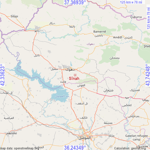
Sīnah GPS coordinates[2]
36° 48' 30.636" North, 43° 2' 21.66" East
| Map corner | latitude | longitude |
|---|---|---|
| Upper-left | 37.36939°, | 42.33623° |
| Center: | 36.80851°, | 43.03935° |
| Lower-right: | 36.24349°, | 43.74248° |
| Map W x H: | 125.2×125.2 km | = 77.8×77.8mi |
| max Lat: | 37.22781° ⇑8.5% North |
| Sīnah: | 36.80851° |
| min Lat: | ⇓91.5% South 29.97421° |
| min Long | Sīnah | max Long |
| 40.28586° | 43.03935° | 48.47309° |
| W 13.4%⇐ | ⇒86.6% E |
Elevation
Elevation of Sīnah is 669 m = 2195 ft, and this is 376 m = 1234 ft above average elevation for this country.
| Max E: |
1316 m = 4318 ft | 15.5% |
| Sīnah | 669 m 2195 ft | |
| Avg. | 293 m = 961 ft | |
Min E: |
1 m = 3 ft | 84.5% |
See also: Sīnah elevation on elevation.city.
Geographical zone
Sīnah is located in North temperate zone (between Tropic of Cancer and the Arctic Circle). Distance of this Northern Tropic circle is 1486.8 km =923.9 mi to South.| Distance of | km | miles | from Sīnah |
|---|---|---|---|
| North Pole | 5914.3 | 3675 | to North |
| Arctic Circle | 3308.5 | 2055.8 | to North |
| Tropic Cancer | 1486.8 | 923.9 | to South |
| Equator | 4092.7 | 2543.1 | to South |


Nearby cities:
15 places around Sīnah: (largest is in red/bold)
• Ain Nuni
58.5 km =36.4 mi,  37°
37°
• Al Mawşil al Jadīdah
53.2 km =33.1 mi,  173°
173°
• Al ‘Amādīyah
50.8 km =31.6 mi,  51°
51°
• Ash Shaykhān
30.5 km =19 mi,  114°
114°
• Batifa
40.8 km =25.4 mi,  356°
356°
• Bāmarnī
40.4 km =25.1 mi,  30°
30°
• Derkar
47.5 km =29.5 mi,  336°
336°
• Dihok
7.9 km =4.9 mi,  325°
325°
• Ibrāhīm al Khalīl
55.6 km =34.5 mi,  311°
311°
• Mosul
53.1 km =33 mi, 172°
• Saymayl
17.9 km =11.1 mi,  288°
288°
• Tallkayf
36 km =22.4 mi, 168°
• Zaxo
49.2 km =30.6 mi,  320°
320°
• Zaxu
48.9 km =30.4 mi, 319°
• Zāwītah
14.3 km =8.9 mi, 41°
Sources, notices
• [Note1] Compared only with cities in Iraq existing in our database
• [Src1] Map data: © OpenStreetMap contributors (CC-BY-SA)
• [Src2] Other city data from geonames.org with taken over terms of usage.
• [Src3] Geographical zone / Annual Mean Temperature by Robert A. Rohde @ Wikipedia
