Ash Shaykhān geodata
Ash Shaykhān (Nineveh) is a seat of a second-order administrative division; located in Iraq in Asia/Baghdad (GMT+3) time zone. In our database, there are 71 cities with bigger population. Compared to other cities in Iraq, 90.1% of cities are located further ↓South; 80.3% of cities are located further →East and 77.5% of cities have lower elevation than Ash Shaykhān. Note1


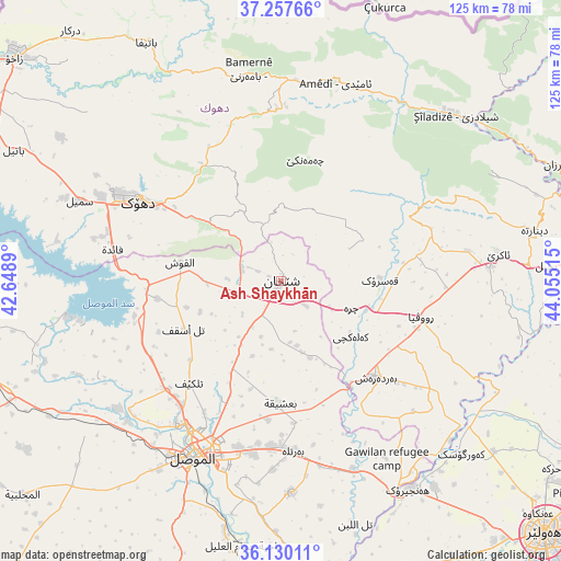
Ash Shaykhān GPS coordinates[2]
36° 41' 45.42" North, 43° 21' 7.272" East
| Map corner | latitude | longitude |
|---|---|---|
| Upper-left | 37.25766°, | 42.6489° |
| Center: | 36.69595°, | 43.35202° |
| Lower-right: | 36.13011°, | 44.05515° |
| Map W x H: | 125.4×125.4 km | = 77.9×77.9mi |
| max Lat: | 37.22781° ⇑9.9% North |
| Ash Shaykhān: | 36.69595° |
| min Lat: | ⇓90.1% South 29.97421° |
| min Long | Ash Shaykhān | max Long |
| 40.28586° | 43.35202° | 48.47309° |
| W 19.7%⇐ | ⇒80.3% E |
Elevation
Elevation of Ash Shaykhān is 512 m = 1680 ft, and this is 219 m = 719 ft above average elevation for this country.
| Max E: |
1316 m = 4318 ft | 22.5% |
| Ash Shaykhān | 512 m 1680 ft | |
| Avg. | 293 m = 961 ft | |
Min E: |
1 m = 3 ft | 77.5% |
See also: Iraq elevation on elevation.city.
Geographical zone
Ash Shaykhān is located in North temperate zone (between Tropic of Cancer and the Arctic Circle). Distance of this Northern Tropic circle is 1474.3 km =916.1 mi to South.| Distance of | km | miles | from Ash Shaykhān |
|---|---|---|---|
| North Pole | 5926.9 | 3682.8 | to North |
| Arctic Circle | 3321 | 2063.6 | to North |
| Tropic Cancer | 1474.3 | 916.1 | to South |
| Equator | 4080.2 | 2535.3 | to South |


Nearby cities:
15 places around Ash Shaykhān: (largest is in red/bold)
• Ain Nuni
59.6 km =37 mi,  7°
7°
• Al Mawşil al Jadīdah
46 km =28.6 mi,  208°
208°
• Al ‘Amādīyah
45.7 km =28.4 mi,  15°
15°
• Al-Hamdaniya
47.3 km =29.4 mi,  177°
177°
• Batifa
61.2 km =38 mi,  330°
330°
• Bāmarnī
47.9 km =29.8 mi,  351°
351°
• Derkar
73.1 km =45.4 mi,  320°
320°
• Dihok
37.6 km =23.4 mi,  300°
300°
• Mosul
45.2 km =28.1 mi, 207°
• Saymayl
48.4 km =30.1 mi,  291°
291°
• Sīnah
30.5 km =19 mi, 294°
• Tallkayf
30.7 km =19.1 mi,  222°
222°
• Xebat
54.5 km =33.9 mi,  148°
148°
• Zāwītah
29.7 km =18.5 mi, 321°
• ‘Aqrah
48.9 km =30.4 mi,  81°
81°
Sources, notices
• [Note1] Compared only with cities in Iraq existing in our database
• [Src1] Map data: © OpenStreetMap contributors (CC-BY-SA)
• [Src2] Other city data from geonames.org with taken over terms of usage.
• [Src3] Geographical zone / Annual Mean Temperature by Robert A. Rohde @ Wikipedia
