Dihok geodata
Dihok (Dahūk) is a seat of a first-order administrative division; located in Iraq in Asia/Baghdad (GMT+3) time zone. With population of 284,000 people, there are 16 cities with bigger population in this country. Compared to other cities in Iraq, 93.7% of cities are located further ↓South; 88% of cities are located further →East and 79.6% of cities have lower elevation than Dihok. Note1


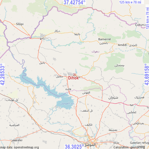
Dihok GPS coordinates[2]
36° 52' 1.524" North, 42° 59' 18.42" East
| Map corner | latitude | longitude |
|---|---|---|
| Upper-left | 37.42754°, | 42.28533° |
| Center: | 36.86709°, | 42.98845° |
| Lower-right: | 36.3025°, | 43.69158° |
| Map W x H: | 125.1×125.1 km | = 77.7×77.7mi |
| max Lat: | 37.22781° ⇑6.3% North |
| Dihok: | 36.86709° |
| min Lat: | ⇓93.7% South 29.97421° |
| min Long | Dihok | max Long |
| 40.28586° | 42.98845° | 48.47309° |
| W 12%⇐ | ⇒88% E |
Elevation
Elevation of Dihok is 567 m = 1860 ft, and this is 274 m = 899 ft above average elevation for this country.
| Max E: |
1316 m = 4318 ft | 20.4% |
| Dihok | 567 m 1860 ft | |
| Avg. | 293 m = 961 ft | |
Min E: |
1 m = 3 ft | 79.6% |
See also: Dihok elevation on elevation.city.
Geographical zone
Dihok is located in North temperate zone (between Tropic of Cancer and the Arctic Circle). Distance of this Northern Tropic circle is 1493.3 km =927.9 mi to South.| Distance of | km | miles | from Dihok |
|---|---|---|---|
| North Pole | 5907.8 | 3670.9 | to North |
| Arctic Circle | 3301.9 | 2051.7 | to North |
| Tropic Cancer | 1493.3 | 927.9 | to South |
| Equator | 4099.2 | 2547.1 | to South |


Nearby cities:
15 places around Dihok: (largest is in red/bold)
• Ain Nuni
56.5 km =35.1 mi,  44°
44°
• Al Mawşil al Jadīdah
60.3 km =37.5 mi,  170°
170°
• Al ‘Amādīyah
50.9 km =31.6 mi,  60°
60°
• Ash Shaykhān
37.6 km =23.4 mi,  120°
120°
• Batifa
34.3 km =21.3 mi,  3°
3°
• Bāmarnī
37.8 km =23.5 mi, 41°
• Derkar
39.8 km =24.7 mi,  338°
338°
• Ibrāhīm al Khalīl
48 km =29.8 mi,  309°
309°
• Mosul
60.3 km =37.5 mi, 168°
• Saymayl
12.5 km =7.8 mi,  265°
265°
• Sīnah
7.9 km =4.9 mi,  145°
145°
• Tallkayf
43.4 km =27 mi,  164°
164°
• Zaxo
41.3 km =25.7 mi,  319°
319°
• Zaxu
41 km =25.5 mi, 318°
• Zāwītah
14.5 km =9 mi,  72°
72°
Sources, notices
• [Note1] Compared only with cities in Iraq existing in our database
• [Src1] Map data: © OpenStreetMap contributors (CC-BY-SA)
• [Src2] Other city data from geonames.org with taken over terms of usage.
• [Src3] Geographical zone / Annual Mean Temperature by Robert A. Rohde @ Wikipedia
