Mosul geodata
Mosul (Nineveh) is a seat of a first-order administrative division; located in Iraq in Asia/Baghdad (GMT+3) time zone. With population of 1,739,800 people, there are 4 cities with bigger population in this country. Compared to other cities in Iraq, 85.2% of cities are located further ↓South; 85.2% of cities are located further →East and 61.3% of cities have lower elevation than Mosul. Note1


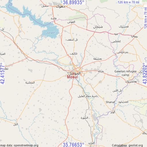
Mosul GPS coordinates[2]
36° 20' 6" North, 43° 7' 8.004" East
| Map corner | latitude | longitude |
|---|---|---|
| Upper-left | 36.89935°, | 42.41577° |
| Center: | 36.335°, | 43.11889° |
| Lower-right: | 35.76653°, | 43.82202° |
| Map W x H: | 126×126 km | = 78.3×78.3mi |
| max Lat: | 37.22781° ⇑14.8% North |
| Mosul: | 36.335° |
| min Lat: | ⇓85.2% South 29.97421° |
| min Long | Mosul | max Long |
| 40.28586° | 43.11889° | 48.47309° |
| W 14.8%⇐ | ⇒85.2% E |
Elevation
Elevation of Mosul is 228 m = 748 ft, and this is 65 m = 213 ft below average elevation for this country.
| Max E: |
1316 m = 4318 ft | 38.7% |
| Avg. | 293 m = 961 ft | |
| Mosul | 228 m = 748 ft | |
Min E: |
1 m = 3 ft | 61.3% |
See also: Mosul elevation on elevation.city.
Geographical zone
Mosul is located in North temperate zone (between Tropic of Cancer and the Arctic Circle). Distance of this Northern Tropic circle is 1434.2 km =891.2 mi to South.| Distance of | km | miles | from Mosul |
|---|---|---|---|
| North Pole | 5967 | 3707.7 | to North |
| Arctic Circle | 3361.1 | 2088.5 | to North |
| Tropic Cancer | 1434.2 | 891.2 | to South |
| Equator | 4040.1 | 2510.4 | to South |


Nearby cities:
15 places around Mosul: (largest is in red/bold)
• Al Mawşil al Jadīdah
1.2 km =0.7 mi,  257°
257°
• Al Qayyārah
61.6 km =38.3 mi,  165°
165°
• Al-Hamdaniya
24.3 km =15.1 mi,  107°
107°
• Ash Shaykhān
45.2 km =28.1 mi,  27°
27°
• Beḧirke
82.1 km =51 mi,  91°
91°
• Dihok
60.3 km =37.5 mi,  348°
348°
• Erbil
81.8 km =50.8 mi,  101°
101°
• Mexmur
74.7 km =46.4 mi,  146°
146°
• Saymayl
63 km =39.1 mi,  337°
337°
• Sīnah
53.1 km =33 mi, 352°
• Tall ‘Afar
60.3 km =37.5 mi,  274°
274°
• Tallkayf
17.4 km =10.8 mi,  0°
0°
• Xebat
49.8 km =30.9 mi, 97°
• Zāwītah
63.5 km =39.5 mi, 2°
• ‘Aynkāwah
79.3 km =49.3 mi, 98°
In other languages:
- In France: Mossoul
- In German: Mossul
- In Italian: Mossul
- In Russian: Мосул
- In Chinese: 摩苏尔
Sources, notices
• [Note1] Compared only with cities in Iraq existing in our database
• [Src1] Map data: © OpenStreetMap contributors (CC-BY-SA)
• [Src2] Other city data from geonames.org with taken over terms of usage.
• [Src3] Geographical zone / Annual Mean Temperature by Robert A. Rohde @ Wikipedia
