Batifa geodata
Batifa (Dahūk) is a seat of a third-order administrative division; located in Iraq in Asia/Baghdad (GMT+3) time zone. With population of 26,000 people, there are 59 cities with bigger population in this country. Compared to other cities in Iraq, 98.6% of cities are located further ↓South; 87.3% of cities are located further →East and 90.1% of cities have lower elevation than Batifa. Note1


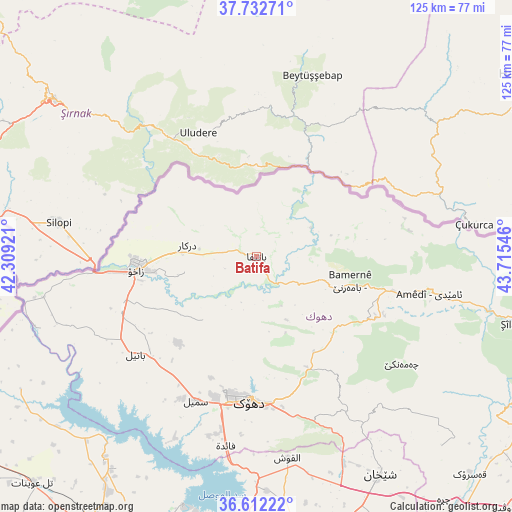
Batifa GPS coordinates[2]
37° 10' 28.344" North, 43° 0' 44.388" East
| Map corner | latitude | longitude |
|---|---|---|
| Upper-left | 37.73271°, | 42.30921° |
| Center: | 37.17454°, | 43.01233° |
| Lower-right: | 36.61222°, | 43.71546° |
| Map W x H: | 124.6×124.6 km | = 77.4×77.4mi |
| max Lat: | 37.22781° ⇑1.4% North |
| Batifa: | 37.17454° |
| min Lat: | ⇓98.6% South 29.97421° |
| min Long | Batifa | max Long |
| 40.28586° | 43.01233° | 48.47309° |
| W 12.7%⇐ | ⇒87.3% E |
Elevation
Elevation of Batifa is 860 m = 2822 ft, and this is 567 m = 1860 ft above average elevation for this country.
| Max E: |
1316 m = 4318 ft | 9.9% |
| Batifa | 860 m 2822 ft | |
| Avg. | 293 m = 961 ft | |
Min E: |
1 m = 3 ft | 90.1% |
See also: Iraq elevation on elevation.city.
Geographical zone
Batifa is located in North temperate zone (between Tropic of Cancer and the Arctic Circle). Distance of this Northern Tropic circle is 1527.5 km =949.1 mi to South.| Distance of | km | miles | from Batifa |
|---|---|---|---|
| North Pole | 5873.6 | 3649.7 | to North |
| Arctic Circle | 3267.8 | 2030.5 | to North |
| Tropic Cancer | 1527.5 | 949.1 | to South |
| Equator | 4133.4 | 2568.4 | to South |


Nearby cities:
15 places around Batifa: (largest is in red/bold)
• Ain Nuni
38.1 km =23.7 mi,  81°
81°
• Al ‘Amādīyah
43.1 km =26.8 mi,  102°
102°
• Ash Shaykhān
61.2 km =38 mi,  150°
150°
• Bāmarnī
23.7 km =14.7 mi, 104°
• Derkar
17 km =10.6 mi,  279°
279°
• Dihok
34.3 km =21.3 mi,  183°
183°
• Ibrāhīm al Khalīl
39.4 km =24.5 mi,  264°
264°
• Mosul
93.8 km =58.3 mi,  174°
174°
• Saymayl
38.1 km =23.7 mi,  202°
202°
• Sīnah
40.8 km =25.4 mi, 176°
• Tallkayf
76.6 km =47.6 mi, 172°
• Zaxo
29.1 km =18.1 mi, 264°
• Zaxu
29.5 km =18.3 mi, 263°
• Zāwītah
32.1 km =19.9 mi,  158°
158°
• ‘Aqrah
90.9 km =56.5 mi,  120°
120°
Sources, notices
• [Note1] Compared only with cities in Iraq existing in our database
• [Src1] Map data: © OpenStreetMap contributors (CC-BY-SA)
• [Src2] Other city data from geonames.org with taken over terms of usage.
• [Src3] Geographical zone / Annual Mean Temperature by Robert A. Rohde @ Wikipedia
