Tallkayf geodata
Tallkayf (Nineveh) is a seat of a second-order administrative division; located in Iraq in Asia/Baghdad (GMT+3) time zone. With population of 23,524 people, there are 60 cities with bigger population in this country. Compared to other cities in Iraq, 87.3% of cities are located further ↓South; 84.5% of cities are located further →East and 65.5% of cities have lower elevation than Tallkayf. Note1


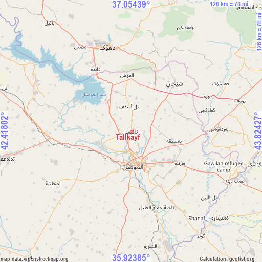
Tallkayf GPS coordinates[2]
36° 29' 28.248" North, 43° 7' 16.104" East
| Map corner | latitude | longitude |
|---|---|---|
| Upper-left | 37.05439°, | 42.41802° |
| Center: | 36.49118°, | 43.12114° |
| Lower-right: | 35.92385°, | 43.82427° |
| Map W x H: | 125.7×125.7 km | = 78.1×78.1mi |
| max Lat: | 37.22781° ⇑12.7% North |
| Tallkayf: | 36.49118° |
| min Lat: | ⇓87.3% South 29.97421° |
| min Long | Tallkayf | max Long |
| 40.28586° | 43.12114° | 48.47309° |
| W 15.5%⇐ | ⇒84.5% E |
Elevation
Elevation of Tallkayf is 279 m = 915 ft, and this is 14 m = 46 ft below average elevation for this country.
| Max E: |
1316 m = 4318 ft | 34.5% |
| Avg. | 293 m = 961 ft | |
| Tallkayf | 279 m = 915 ft | |
Min E: |
1 m = 3 ft | 65.5% |
See also: Iraq elevation on elevation.city.
Geographical zone
Tallkayf is located in North temperate zone (between Tropic of Cancer and the Arctic Circle). Distance of this Northern Tropic circle is 1451.5 km =901.9 mi to South.| Distance of | km | miles | from Tallkayf |
|---|---|---|---|
| North Pole | 5949.6 | 3696.9 | to North |
| Arctic Circle | 3343.7 | 2077.7 | to North |
| Tropic Cancer | 1451.5 | 901.9 | to South |
| Equator | 4057.4 | 2521.2 | to South |


Nearby cities:
15 places around Tallkayf: (largest is in red/bold)
• Al Mawşil al Jadīdah
17.7 km =11 mi,  184°
184°
• Al Qayyārah
78.5 km =48.8 mi,  168°
168°
• Al ‘Amādīyah
74.4 km =46.2 mi,  26°
26°
• Al-Hamdaniya
33.6 km =20.9 mi,  136°
136°
• Ash Shaykhān
30.7 km =19.1 mi,  42°
42°
• Batifa
76.6 km =47.6 mi,  352°
352°
• Bāmarnī
71.4 km =44.4 mi,  10°
10°
• Dihok
43.4 km =27 mi,  344°
344°
• Mosul
17.4 km =10.8 mi, 180°
• Saymayl
47.5 km =29.5 mi,  329°
329°
• Sīnah
36 km =22.4 mi, 348°
• Tall ‘Afar
61.5 km =38.2 mi,  258°
258°
• Xebat
54.6 km =33.9 mi,  115°
115°
• Zāwītah
46.1 km =28.6 mi,  2°
2°
• ‘Aqrah
75.2 km =46.7 mi,  66°
66°
Sources, notices
• [Note1] Compared only with cities in Iraq existing in our database
• [Src1] Map data: © OpenStreetMap contributors (CC-BY-SA)
• [Src2] Other city data from geonames.org with taken over terms of usage.
• [Src3] Geographical zone / Annual Mean Temperature by Robert A. Rohde @ Wikipedia
