Ain Nuni geodata
Ain Nuni (Dahūk) is a seat of a third-order administrative division; located in Iraq in Asia/Baghdad (GMT+3) time zone. In our database, there are 71 cities with bigger population. Compared to other cities in Iraq, 100% of cities are located further ↓South; 78.9% of cities are located further →East and 97.2% of cities have lower elevation than Ain Nuni. Note1


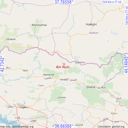
Ain Nuni GPS coordinates[2]
37° 13' 40.116" North, 43° 26' 14.352" East
| Map corner | latitude | longitude |
|---|---|---|
| Upper-left | 37.78558°, | 42.7342° |
| Center: | 37.22781°, | 43.43732° |
| Lower-right: | 36.66588°, | 44.14045° |
| Map W x H: | 124.5×124.5 km | = 77.4×77.4mi |
| max Lat: | 37.22781° ⇑0% North |
| Ain Nuni: | 37.22781° |
| min Lat: | ⇓100% South 29.97421° |
| min Long | Ain Nuni | max Long |
| 40.28586° | 43.43732° | 48.47309° |
| W 21.1%⇐ | ⇒78.9% E |
Elevation
Elevation of Ain Nuni is 1230 m = 4035 ft, and this is 937 m = 3074 ft above average elevation for this country.
| Max E: |
1316 m = 4318 ft | 2.8% |
| Ain Nuni | 1230 m 4035 ft | |
| Avg. | 293 m = 961 ft | |
Min E: |
1 m = 3 ft | 97.2% |
See also: Iraq elevation on elevation.city.
Geographical zone
Ain Nuni is located in North temperate zone (between Tropic of Cancer and the Arctic Circle). Distance of this Northern Tropic circle is 1533.4 km =952.8 mi to South.| Distance of | km | miles | from Ain Nuni |
|---|---|---|---|
| North Pole | 5867.7 | 3646 | to North |
| Arctic Circle | 3261.8 | 2026.8 | to North |
| Tropic Cancer | 1533.4 | 952.8 | to South |
| Equator | 4139.3 | 2572 | to South |


Nearby cities:
15 places around Ain Nuni: (largest is in red/bold)
• Al ‘Amādīyah
15.7 km =9.8 mi,  163°
163°
• Ash Shaykhān
59.6 km =37 mi,  187°
187°
• Batifa
38.1 km =23.7 mi,  261°
261°
• Bāmarnī
18.9 km =11.7 mi,  231°
231°
• Derkar
54.4 km =33.8 mi,  266°
266°
• Dihok
56.5 km =35.1 mi,  224°
224°
• Ibrāhīm al Khalīl
77.5 km =48.2 mi, 262°
• Mêrgasur
88 km =54.7 mi,  119°
119°
• Saymayl
66.5 km =41.3 mi, 231°
• Sīnah
58.5 km =36.4 mi, 217°
• Tallkayf
86.6 km =53.8 mi,  198°
198°
• Zaxo
67.1 km =41.7 mi, 262°
• Zaxu
67.6 km =42 mi, 261°
• Zāwītah
44.3 km =27.5 mi, 215°
• ‘Aqrah
65.9 km =40.9 mi,  142°
142°
Sources, notices
• [Note1] Compared only with cities in Iraq existing in our database
• [Src1] Map data: © OpenStreetMap contributors (CC-BY-SA)
• [Src2] Other city data from geonames.org with taken over terms of usage.
• [Src3] Geographical zone / Annual Mean Temperature by Robert A. Rohde @ Wikipedia
