‘Aqrah geodata
‘Aqrah (Nineveh) is a seat of a second-order administrative division; located in Iraq in Asia/Baghdad (GMT+3) time zone. With population of 23,000 people, there are 62 cities with bigger population in this country. Compared to other cities in Iraq, 90.8% of cities are located further ↓South; 69.7% of cities are located further →East and 87.3% of cities have lower elevation than ‘Aqrah. Note1


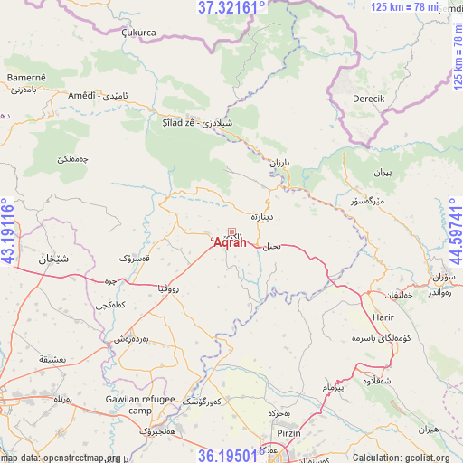
‘Aqrah GPS coordinates[2]
36° 45' 37.368" North, 43° 53' 39.408" East
| Map corner | latitude | longitude |
|---|---|---|
| Upper-left | 37.32161°, | 43.19116° |
| Center: | 36.76038°, | 43.89428° |
| Lower-right: | 36.19501°, | 44.59741° |
| Map W x H: | 125.3×125.3 km | = 77.9×77.9mi |
| max Lat: | 37.22781° ⇑9.2% North |
| ‘Aqrah: | 36.76038° |
| min Lat: | ⇓90.8% South 29.97421° |
| min Long | ‘Aqrah | max Long |
| 40.28586° | 43.89428° | 48.47309° |
| W 30.3%⇐ | ⇒69.7% E |
Elevation
Elevation of ‘Aqrah is 716 m = 2349 ft, and this is 423 m = 1388 ft above average elevation for this country.
| Max E: |
1316 m = 4318 ft | 12.7% |
| ‘Aqrah | 716 m 2349 ft | |
| Avg. | 293 m = 961 ft | |
Min E: |
1 m = 3 ft | 87.3% |
See also: Iraq elevation on elevation.city.
Geographical zone
‘Aqrah is located in North temperate zone (between Tropic of Cancer and the Arctic Circle). Distance of this Northern Tropic circle is 1481.5 km =920.6 mi to South.| Distance of | km | miles | from ‘Aqrah |
|---|---|---|---|
| North Pole | 5919.7 | 3678.3 | to North |
| Arctic Circle | 3313.8 | 2059.1 | to North |
| Tropic Cancer | 1481.5 | 920.6 | to South |
| Equator | 4087.4 | 2539.8 | to South |


Nearby cities:
15 places around ‘Aqrah: (largest is in red/bold)
• Ain Nuni
65.9 km =40.9 mi,  322°
322°
• Al ‘Amādīyah
51.6 km =32.1 mi, 315°
• Al-Hamdaniya
71.4 km =44.4 mi,  220°
220°
• Ash Shaykhān
48.9 km =30.4 mi,  261°
261°
• Beḧirke
51 km =31.7 mi,  165°
165°
• Bāmarnī
68.4 km =42.5 mi,  305°
305°
• Erbil
65 km =40.4 mi, 170°
• Kasnazān
65.8 km =40.9 mi,  161°
161°
• Mêrgasur
37.4 km =23.2 mi,  76°
76°
• Ruwāndiz
58.5 km =36.4 mi,  106°
106°
• Shaqlāwah
55.2 km =34.3 mi,  135°
135°
• Soran
59.1 km =36.7 mi,  101°
101°
• Xebat
57.2 km =35.5 mi,  200°
200°
• Zāwītah
68.6 km =42.6 mi,  283°
283°
• ‘Aynkāwah
59.6 km =37 mi, 171°
Sources, notices
• [Note1] Compared only with cities in Iraq existing in our database
• [Src1] Map data: © OpenStreetMap contributors (CC-BY-SA)
• [Src2] Other city data from geonames.org with taken over terms of usage.
• [Src3] Geographical zone / Annual Mean Temperature by Robert A. Rohde @ Wikipedia
