Dibis geodata
Dibis (Kirkuk) is a seat of a second-order administrative division; located in Iraq in Asia/Baghdad (GMT+3) time zone. In our database, there are 71 cities with bigger population. Compared to other cities in Iraq, 68.3% of cities are located further ↓South; 64.1% of cities are located further →East and 63.4% of cities have lower elevation than Dibis. Note1


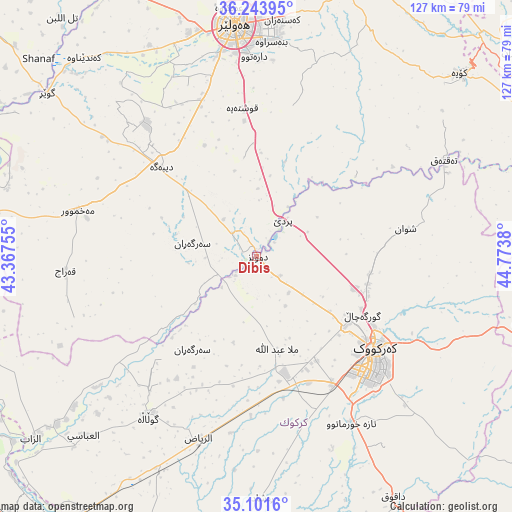
Dibis GPS coordinates[2]
35° 40' 29.352" North, 44° 4' 14.412" East
| Map corner | latitude | longitude |
|---|---|---|
| Upper-left | 36.24395°, | 43.36755° |
| Center: | 35.67482°, | 44.07067° |
| Lower-right: | 35.1016°, | 44.7738° |
| Map W x H: | 127×127 km | = 78.9×78.9mi |
| max Lat: | 37.22781° ⇑31.7% North |
| Dibis: | 35.67482° |
| min Lat: | ⇓68.3% South 29.97421° |
| min Long | Dibis | max Long |
| 40.28586° | 44.07067° | 48.47309° |
| W 35.9%⇐ | ⇒64.1% E |
Elevation
Elevation of Dibis is 242 m = 794 ft, and this is 51 m = 167 ft below average elevation for this country.
| Max E: |
1316 m = 4318 ft | 36.6% |
| Avg. | 293 m = 961 ft | |
| Dibis | 242 m = 794 ft | |
Min E: |
1 m = 3 ft | 63.4% |
See also: Iraq elevation on elevation.city.
Geographical zone
Dibis is located in North temperate zone (between Tropic of Cancer and the Arctic Circle). Distance of this Northern Tropic circle is 1360.7 km =845.5 mi to South.| Distance of | km | miles | from Dibis |
|---|---|---|---|
| North Pole | 6040.4 | 3753.3 | to North |
| Arctic Circle | 3434.5 | 2134.1 | to North |
| Tropic Cancer | 1360.7 | 845.5 | to South |
| Equator | 3966.7 | 2464.8 | to South |


Nearby cities:
15 places around Dibis: (largest is in red/bold)
• Al Qayyārah
71.4 km =44.4 mi,  281°
281°
• Al Ḩawījah
47.3 km =29.4 mi,  214°
214°
• Al ‘Abbāsī
61.8 km =38.4 mi,  224°
224°
• Ar Riyāḑ
47.3 km =29.4 mi,  197°
197°
• Beḧirke
71.3 km =44.3 mi,  357°
357°
• Dare Tû
49.6 km =30.8 mi, 358°
• Dāqūq
68.7 km =42.7 mi,  150°
150°
• Erbil
56.8 km =35.3 mi,  354°
354°
• Jamjamāl
70.8 km =44 mi,  102°
102°
• Kasnazān
58.7 km =36.5 mi,  5°
5°
• Kirkuk
37.1 km =23.1 mi,  128°
128°
• Koysinceq
67.7 km =42.1 mi,  47°
47°
• Mexmur
45.7 km =28.4 mi, 284°
• Qushtepe
36.5 km =22.7 mi, 355°
• ‘Aynkāwah
62.2 km =38.6 mi, 353°
Sources, notices
• [Note1] Compared only with cities in Iraq existing in our database
• [Src1] Map data: © OpenStreetMap contributors (CC-BY-SA)
• [Src2] Other city data from geonames.org with taken over terms of usage.
• [Src3] Geographical zone / Annual Mean Temperature by Robert A. Rohde @ Wikipedia
