Kasnazān geodata
Kasnazān (Arbīl) is a seat of a third-order administrative division; located in Iraq in Asia/Baghdad (GMT+3) time zone. In our database, there are 71 cities with bigger population. Compared to other cities in Iraq, 77.5% of cities are located further ↓South; 63.4% of cities are located further →East and 81% of cities have lower elevation than Kasnazān. Note1


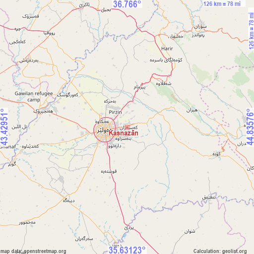
Kasnazān GPS coordinates[2]
36° 12' 2.412" North, 44° 7' 57.468" East
| Map corner | latitude | longitude |
|---|---|---|
| Upper-left | 36.766°, | 43.42951° |
| Center: | 36.20067°, | 44.13263° |
| Lower-right: | 35.63123°, | 44.83576° |
| Map W x H: | 126.2×126.2 km | = 78.4×78.4mi |
| max Lat: | 37.22781° ⇑22.5% North |
| Kasnazān: | 36.20067° |
| min Lat: | ⇓77.5% South 29.97421° |
| min Long | Kasnazān | max Long |
| 40.28586° | 44.13263° | 48.47309° |
| W 36.6%⇐ | ⇒63.4% E |
Elevation
Elevation of Kasnazān is 587 m = 1926 ft, and this is 294 m = 965 ft above average elevation for this country.
| Max E: |
1316 m = 4318 ft | 19% |
| Kasnazān | 587 m 1926 ft | |
| Avg. | 293 m = 961 ft | |
Min E: |
1 m = 3 ft | 81% |
See also: Iraq elevation on elevation.city.
Geographical zone
Kasnazān is located in North temperate zone (between Tropic of Cancer and the Arctic Circle). Distance of this Northern Tropic circle is 1419.2 km =881.8 mi to South.| Distance of | km | miles | from Kasnazān |
|---|---|---|---|
| North Pole | 5981.9 | 3717 | to North |
| Arctic Circle | 3376 | 2097.7 | to North |
| Tropic Cancer | 1419.2 | 881.8 | to South |
| Equator | 4025.1 | 2501.1 | to South |


Nearby cities:
15 places around Kasnazān: (largest is in red/bold)
• Beḧirke
15.5 km =9.6 mi,  325°
325°
• Dare Tû
11 km =6.8 mi,  216°
216°
• Dibis
58.7 km =36.5 mi,  185°
185°
• Erbil
11 km =6.8 mi,  259°
259°
• Hīrān
33.5 km =20.8 mi,  75°
75°
• Koysinceq
46.4 km =28.8 mi,  106°
106°
• Nāḩiyat Hīrān
33.1 km =20.6 mi,  74°
74°
• Qushtepe
23.7 km =14.7 mi,  200°
200°
• Ruwāndiz
57.6 km =35.8 mi,  37°
37°
• Shaqlāwah
28.5 km =17.7 mi, 37°
• Soran
62.3 km =38.7 mi, 36°
• Xebat
42.3 km =26.3 mi,  281°
281°
• Ṟaniye
67.5 km =41.9 mi, 84°
• ‘Aqrah
65.8 km =40.9 mi,  341°
341°
• ‘Aynkāwah
12.8 km =8 mi,  285°
285°
Sources, notices
• [Note1] Compared only with cities in Iraq existing in our database
• [Src1] Map data: © OpenStreetMap contributors (CC-BY-SA)
• [Src2] Other city data from geonames.org with taken over terms of usage.
• [Src3] Geographical zone / Annual Mean Temperature by Robert A. Rohde @ Wikipedia
