Al Ḩawījah geodata
Al Ḩawījah (Kirkuk) is a seat of a second-order administrative division; located in Iraq in Asia/Baghdad (GMT+3) time zone. In our database, there are 71 cities with bigger population. Compared to other cities in Iraq, 62.7% of cities are located further ↓South; 72.5% of cities are located further →East and 57% of cities have lower elevation than Al Ḩawījah. Note1


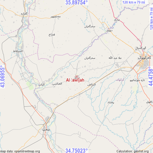
Al Ḩawījah GPS coordinates[2]
35° 19' 33.312" North, 43° 46' 21.612" East
| Map corner | latitude | longitude |
|---|---|---|
| Upper-left | 35.89754°, | 43.06955° |
| Center: | 35.32592°, | 43.77267° |
| Lower-right: | 34.75023°, | 44.4758° |
| Map W x H: | 127.6×127.6 km | = 79.3×79.3mi |
| max Lat: | 37.22781° ⇑37.3% North |
| Al Ḩawījah: | 35.32592° |
| min Lat: | ⇓62.7% South 29.97421° |
| min Long | Al Ḩawījah | max Long |
| 40.28586° | 43.77267° | 48.47309° |
| W 27.5%⇐ | ⇒72.5% E |
Elevation
Elevation of Al Ḩawījah is 192 m = 630 ft, and this is 101 m = 331 ft below average elevation for this country.
| Max E: |
1316 m = 4318 ft | 43% |
| Avg. | 293 m = 961 ft | |
| Al Ḩawījah | 192 m = 630 ft | |
Min E: |
1 m = 3 ft | 57% |
See also: Iraq elevation on elevation.city.
Geographical zone
Al Ḩawījah is located in North temperate zone (between Tropic of Cancer and the Arctic Circle). Distance of this Northern Tropic circle is 1322 km =821.5 mi to South.| Distance of | km | miles | from Al Ḩawījah |
|---|---|---|---|
| North Pole | 6079.2 | 3777.4 | to North |
| Arctic Circle | 3473.3 | 2158.2 | to North |
| Tropic Cancer | 1322 | 821.5 | to South |
| Equator | 3927.9 | 2440.7 | to South |


Nearby cities:
15 places around Al Ḩawījah: (largest is in red/bold)
• Ad Dawr
96.7 km =60.1 mi,  178°
178°
• Al Qayyārah
68.1 km =42.3 mi,  320°
320°
• Al ‘Abbāsī
17 km =10.6 mi,  250°
250°
• Al ‘Awjah
88.2 km =54.8 mi, 182°
• Ar Riyāḑ
14 km =8.7 mi,  116°
116°
• Ash Sharqāt
53.7 km =33.4 mi,  293°
293°
• Bayjī
51.1 km =31.8 mi,  210°
210°
• Dare Tû
92.1 km =57.2 mi,  16°
16°
• Dibis
47.3 km =29.4 mi,  34°
34°
• Dāqūq
64.8 km =40.3 mi,  108°
108°
• Kirkuk
58.3 km =36.2 mi,  74°
74°
• Mexmur
53 km =32.9 mi,  340°
340°
• Qushtepe
78.9 km =49 mi, 17°
• Tikrīt
79.4 km =49.3 mi,  186°
186°
• Tozkhurmato
92.1 km =57.2 mi, 121°
Sources, notices
• [Note1] Compared only with cities in Iraq existing in our database
• [Src1] Map data: © OpenStreetMap contributors (CC-BY-SA)
• [Src2] Other city data from geonames.org with taken over terms of usage.
• [Src3] Geographical zone / Annual Mean Temperature by Robert A. Rohde @ Wikipedia
