Erbil geodata
Erbil (Arbīl) is a seat of a first-order administrative division; located in Iraq in Asia/Baghdad (GMT+3) time zone. With population of 932,800 people, there are 5 cities with bigger population in this country. Compared to other cities in Iraq, 76.8% of cities are located further ↓South; 67.6% of cities are located further →East and 71.8% of cities have lower elevation than Erbil. Note1


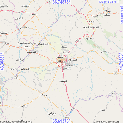
Erbil GPS coordinates[2]
36° 10' 59.988" North, 44° 0' 42.948" East
| Map corner | latitude | longitude |
|---|---|---|
| Upper-left | 36.74878°, | 43.30881° |
| Center: | 36.18333°, | 44.01193° |
| Lower-right: | 35.61376°, | 44.71506° |
| Map W x H: | 126.2×126.2 km | = 78.4×78.4mi |
| max Lat: | 37.22781° ⇑23.2% North |
| Erbil: | 36.18333° |
| min Lat: | ⇓76.8% South 29.97421° |
| min Long | Erbil | max Long |
| 40.28586° | 44.01193° | 48.47309° |
| W 32.4%⇐ | ⇒67.6% E |
Elevation
Elevation of Erbil is 428 m = 1404 ft, and this is 135 m = 443 ft above average elevation for this country.
| Max E: |
1316 m = 4318 ft | 28.2% |
| Erbil | 428 m 1404 ft | |
| Avg. | 293 m = 961 ft | |
Min E: |
1 m = 3 ft | 71.8% |
See also: Erbil elevation on elevation.city.
Geographical zone
Erbil is located in North temperate zone (between Tropic of Cancer and the Arctic Circle). Distance of this Northern Tropic circle is 1417.3 km =880.7 mi to South.| Distance of | km | miles | from Erbil |
|---|---|---|---|
| North Pole | 5983.9 | 3718.2 | to North |
| Arctic Circle | 3378 | 2099 | to North |
| Tropic Cancer | 1417.3 | 880.7 | to South |
| Equator | 4023.2 | 2499.9 | to South |


Nearby cities:
15 places around Erbil: (largest is in red/bold)
• Al-Hamdaniya
57.7 km =35.9 mi,  279°
279°
• Beḧirke
14.9 km =9.3 mi,  8°
8°
• Dare Tû
8.2 km =5.1 mi,  148°
148°
• Dibis
56.8 km =35.3 mi,  174°
174°
• Hīrān
44.4 km =27.6 mi,  76°
76°
• Kasnazān
11 km =6.8 mi, 79°
• Koysinceq
56.5 km =35.1 mi,  101°
101°
• Mexmur
59.7 km =37.1 mi,  220°
220°
• Nāḩiyat Hīrān
44 km =27.3 mi, 76°
• Qushtepe
20.3 km =12.6 mi, 173°
• Ruwāndiz
66.1 km =41.1 mi,  43°
43°
• Shaqlāwah
37.3 km =23.2 mi,  48°
48°
• Xebat
32.4 km =20.1 mi,  288°
288°
• ‘Aqrah
65 km =40.4 mi,  350°
350°
• ‘Aynkāwah
5.5 km =3.4 mi,  343°
343°
Sources, notices
• [Note1] Compared only with cities in Iraq existing in our database
• [Src1] Map data: © OpenStreetMap contributors (CC-BY-SA)
• [Src2] Other city data from geonames.org with taken over terms of usage.
• [Src3] Geographical zone / Annual Mean Temperature by Robert A. Rohde @ Wikipedia
