Khāliş geodata
Khāliş (Diyālá) is a populated place; located in Iraq in Asia/Baghdad (GMT+3) time zone. With population of 70,046 people, there are 33 cities with bigger population in this country. Compared to other cities in Iraq, 56.3% of cities are located further ↑North; 53.5% of cities are located further ←West and 62.7% of cities have higher elevation than Khāliş. Note1


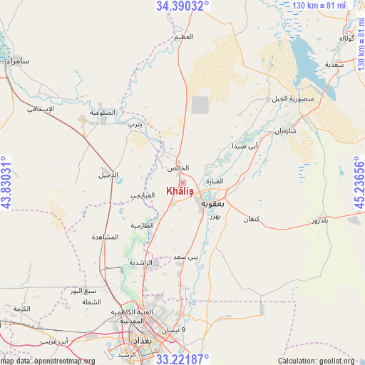
Khāliş GPS coordinates[2]
33° 48' 29.124" North, 44° 32' 0.348" East
| Map corner | latitude | longitude |
|---|---|---|
| Upper-left | 34.39032°, | 43.83031° |
| Center: | 33.80809°, | 44.53343° |
| Lower-right: | 33.22187°, | 45.23656° |
| Map W x H: | 129.9×129.9 km | = 80.7×80.7mi |
| max Lat: | 37.22781° ⇑56.3% North |
| Khāliş: | 33.80809° |
| min Lat: | ⇓43.7% South 29.97421° |
| min Long | Khāliş | max Long |
| 40.28586° | 44.53343° | 48.47309° |
| W 53.5%⇐ | ⇒46.5% E |
Elevation
Elevation of Khāliş is 43 m = 141 ft, and this is 250 m = 820 ft below average elevation for this country.
| Max E: |
1316 m = 4318 ft | 62.7% |
| Avg. | 293 m = 961 ft | |
| Khāliş | 43 m = 141 ft | |
Min E: |
1 m = 3 ft | 37.3% |
See also: Khāliş elevation on elevation.city.
Geographical zone
Khāliş is located in North temperate zone (between Tropic of Cancer and the Arctic Circle). Distance of this Northern Tropic circle is 1153.2 km =716.6 mi to South.| Distance of | km | miles | from Khāliş |
|---|---|---|---|
| North Pole | 6248 | 3882.3 | to North |
| Arctic Circle | 3642.1 | 2263.1 | to North |
| Tropic Cancer | 1153.2 | 716.6 | to South |
| Equator | 3759.1 | 2335.8 | to South |


Nearby cities:
15 places around Khāliş: (largest is in red/bold)
• Abū Ghurayb
64.5 km =40.1 mi,  210°
210°
• Ad Dawr
99.1 km =61.6 mi,  316°
316°
• Ad Dujayl
27.9 km =17.3 mi,  278°
278°
• Al Fallūjah
86 km =53.4 mi,  233°
233°
• Al Khāliş
4.9 km =3 mi,  345°
345°
• Al Maḩmūdīyah
84.4 km =52.4 mi,  190°
190°
• Al Miqdādīyah
41.8 km =26 mi,  63°
63°
• Aţ Ţārmīyah
19.6 km =12.2 mi,  220°
220°
• Baghdad
53.4 km =33.2 mi, 193°
• Balad
42.5 km =26.4 mi,  302°
302°
• Baladrūz
51.8 km =32.2 mi,  103°
103°
• Baqubah
8.9 km =5.5 mi,  132°
132°
• Khānaqīn
99.2 km =61.6 mi,  52°
52°
• Mandalī
94.7 km =58.8 mi,  94°
94°
• Sāmarrā’
73.7 km =45.8 mi,  305°
305°
Sources, notices
• [Note1] Compared only with cities in Iraq existing in our database
• [Src1] Map data: © OpenStreetMap contributors (CC-BY-SA)
• [Src2] Other city data from geonames.org with taken over terms of usage.
• [Src3] Geographical zone / Annual Mean Temperature by Robert A. Rohde @ Wikipedia
